Political Map of Africa: All 54 Countries, Capitals and Borders
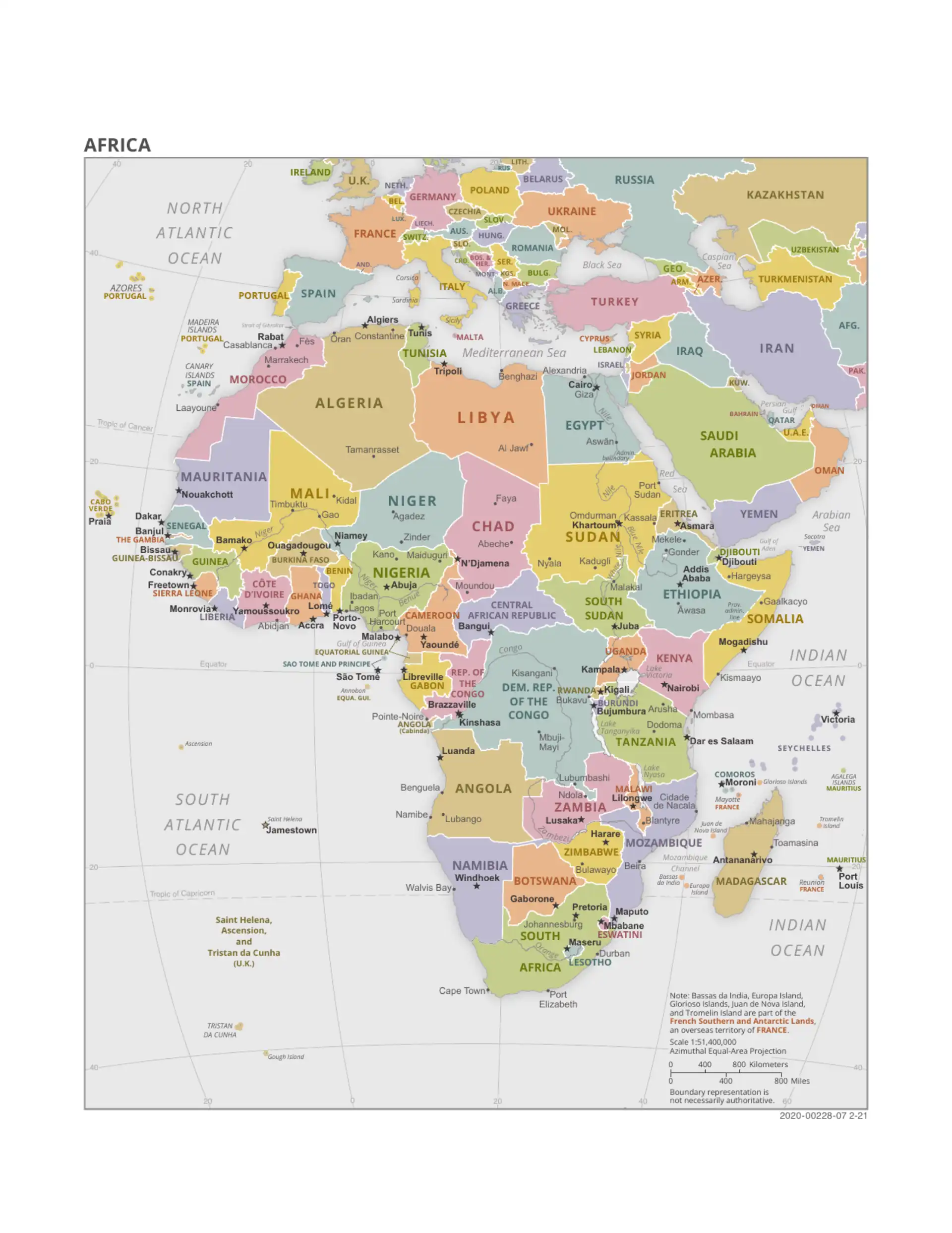
A political map of Africa shows the continent's 54 sovereign countries, their borders and their capital cities. The largest country is Algeria, the most populous is Nigeria, and the smallest is Seychelles. Africa covers about 30.3 million km² and has over 1.4 billion people. Western Sahara appears on most maps as a disputed territory and is not counted among the 54. Below the map you will find every country grouped by region with its capital; click any name for a full country profile.
Last updated: September 2026
How Africa's Political Map Is Organised
The political map of Africa is usually divided into five regions. This page uses a common grouping (6 + 16 + 8 + 15 + 9 = 54). The UN geoscheme differs slightly: it places Angola in Middle (Central) Africa, and Malawi, Mozambique, Zambia and Zimbabwe in Eastern Africa, leaving only five countries in Southern Africa. Countries with more than one capital are noted.
North Africa
Stretching along the Mediterranean and across the Sahara, North Africa links the continent to Europe and the Middle East.
West Africa
The most populous region, West Africa is anchored by Nigeria and coordinated through the ECOWAS bloc.
- Benin – Porto-Novo (official); Cotonou (seat of government)
- Burkina Faso – Ouagadougou
- Cape Verde – Praia
- Ivory Coast (Côte d'Ivoire) – Yamoussoukro (official); Abidjan (economic capital)
- The Gambia – Banjul
- Ghana – Accra
- Guinea – Conakry
- Guinea-Bissau – Bissau
- Liberia – Monrovia
- Mali – Bamako
- Mauritania – Nouakchott
- Niger – Niamey
- Nigeria – Abuja
- Senegal – Dakar
- Sierra Leone – Freetown
- Togo – Lomé
Central Africa
Dominated by the Congo Basin rainforest, Central Africa is the continent's green heart.
- Cameroon – Yaoundé
- Central African Republic – Bangui
- Chad – N'Djamena
- Democratic Republic of the Congo – Kinshasa
- Republic of the Congo – Brazzaville
- Equatorial Guinea – Malabo (Ciudad de la Paz is being built as a future capital)
- Gabon – Libreville
- São Tomé and Príncipe – São Tomé
East Africa
Home to the Great Rift Valley and the Horn, East Africa spans highlands, savannas and the Indian Ocean coast.
- Burundi – Gitega (political capital since 2019); Bujumbura (economic centre)
- Comoros – Moroni
- Djibouti – Djibouti
- Eritrea – Asmara
- Ethiopia – Addis Ababa
- Kenya – Nairobi
- Madagascar – Antananarivo
- Malawi – Lilongwe
- Mauritius – Port Louis
- Rwanda – Kigali
- Seychelles – Victoria
- Somalia – Mogadishu
- South Sudan – Juba
- Tanzania – Dodoma (official); Dar es Salaam (largest city)
- Uganda – Kampala
Southern Africa
From the Kalahari to the Cape, Southern Africa contains the continent's most industrialised economy, South Africa.
- Angola – Luanda
- Botswana – Gaborone
- Eswatini – Mbabane (administrative); Lobamba (royal and legislative)
- Lesotho – Maseru
- Mozambique – Maputo
- Namibia – Windhoek
- South Africa – Pretoria (executive), Cape Town (legislative), Bloemfontein (judicial)
- Zambia – Lusaka
- Zimbabwe – Harare
Reading the Political Map: Borders and Capitals
Two features define every political map of Africa: borders and capitals. Africa's borders are unusually geometric. Many follow straight lines of latitude and longitude because they were drawn by European powers during the Scramble for Africa, under rules agreed at the 1884–1885 Berlin Conference. These colonial boundaries frequently cut across ethnic and linguistic groups, an inheritance that still shapes African politics today.
Capital cities are marked on political maps with a special symbol, usually a star or a dotted circle. A few countries have more than one capital: South Africa famously has three (Pretoria, Cape Town and Bloemfontein), while Nigeria (Lagos to Abuja in 1991), Ivory Coast (Abidjan to Yamoussoukro) and Tanzania (Dar es Salaam to Dodoma) all moved their official capital inland from a larger coastal city, and Burundi moved its political capital from Bujumbura to Gitega in 2019. Explore every capital on our dedicated African capitals page.
Largest and Smallest Countries
The political map of Africa contains striking contrasts in size:
- Largest by area: Algeria (≈2.38 million km²)
- Largest by population: Nigeria (about 230 million people, 2024 UN estimate)
- Smallest mainland country: The Gambia (about 11,300 km²)
- Smallest country overall: Seychelles (about 460 km²)
- Only African country entirely surrounded by another: Lesotho, enclosed by South Africa
- Landlocked countries: 16, from Mali and Niger to Zambia and Zimbabwe (see landlocked countries in Africa)
- Newest country: South Sudan, independent from Sudan since 9 July 2011
Political Map vs Physical Map
A political map answers the question "who governs this land?", while a physical map of Africa answers "what does the land look like?". Physical maps show the Sahara and Kalahari deserts, the Nile and Congo rivers, Lake Victoria, the Atlas Mountains and Mount Kilimanjaro. Both views are essential: borders make more sense once you can see the rivers, mountains and deserts that shaped them. For a country-by-country tour, visit our full list of African countries.
Using This Interactive Political Map
Our interactive map is built on open mapping data, so you can zoom into any region, pan across borders and click through to detailed profiles of all 54 nations. It is a useful resource for:
- Students and teachers studying African geography, capitals and borders
- Travellers planning routes across multiple countries
- Researchers and businesses mapping markets and regional blocs
- Quiz fans – test yourself with our Africa map quiz
Frequently Asked Questions
What is a political map of Africa?
A political map of Africa shows the continent divided into its sovereign states. It highlights international borders, country names, capital cities and major cities, rather than physical features like mountains or rivers. Africa's political map includes 54 sovereign countries.
How many countries are on the political map of Africa?
There are 54 sovereign countries on the political map of Africa, all members of the United Nations. Western Sahara is a disputed territory, which is why some maps show different totals; the African Union has 55 members because it also admits the Sahrawi Arab Democratic Republic.
What is the difference between a political and a physical map of Africa?
A political map emphasises human-made boundaries such as country borders and capital cities, while a physical map emphasises natural features such as the Sahara Desert, the Nile River, the Great Rift Valley and mountain ranges.
Which is the largest country on the political map of Africa?
Algeria is the largest African country by area at about 2.38 million square kilometres. Nigeria is the most populous, with about 230 million people.
Why do many of Africa's borders follow straight lines?
Many of Africa's borders were drawn by European powers during the Scramble for Africa, following rules agreed at the 1884–1885 Berlin Conference. These boundaries often followed lines of latitude and longitude rather than ethnic or geographic divisions, an effect still visible on the political map today.