Guinea: West Africa's Water Tower
Guinea (often called Guinea-Conakry) is a West African country on the Atlantic coast, covering 245,857 km². Its capital and largest city is Conakry, and it has about 15 million people (2025 UN estimate). French is the official language. Guinea borders Guinea-Bissau, Senegal, Mali, Côte d'Ivoire, Liberia and Sierra Leone, and became independent from France on 2 October 1958. Its Fouta Djallon highlands are the source of the Niger, Senegal and Gambia rivers.
The Republic of Guinea, often called Guinea-Conakry to distinguish it from Guinea-Bissau and Equatorial Guinea, serves as West Africa's water tower, with major rivers including the Niger, Senegal, and Gambia originating in its highlands. This mineral-rich nation possesses the world's largest bauxite reserves and significant deposits of gold, diamonds, and iron ore. Despite these natural riches, Guinea remains one of the world's poorest countries, a paradox shaped by colonial exploitation, authoritarian rule, and governance challenges.
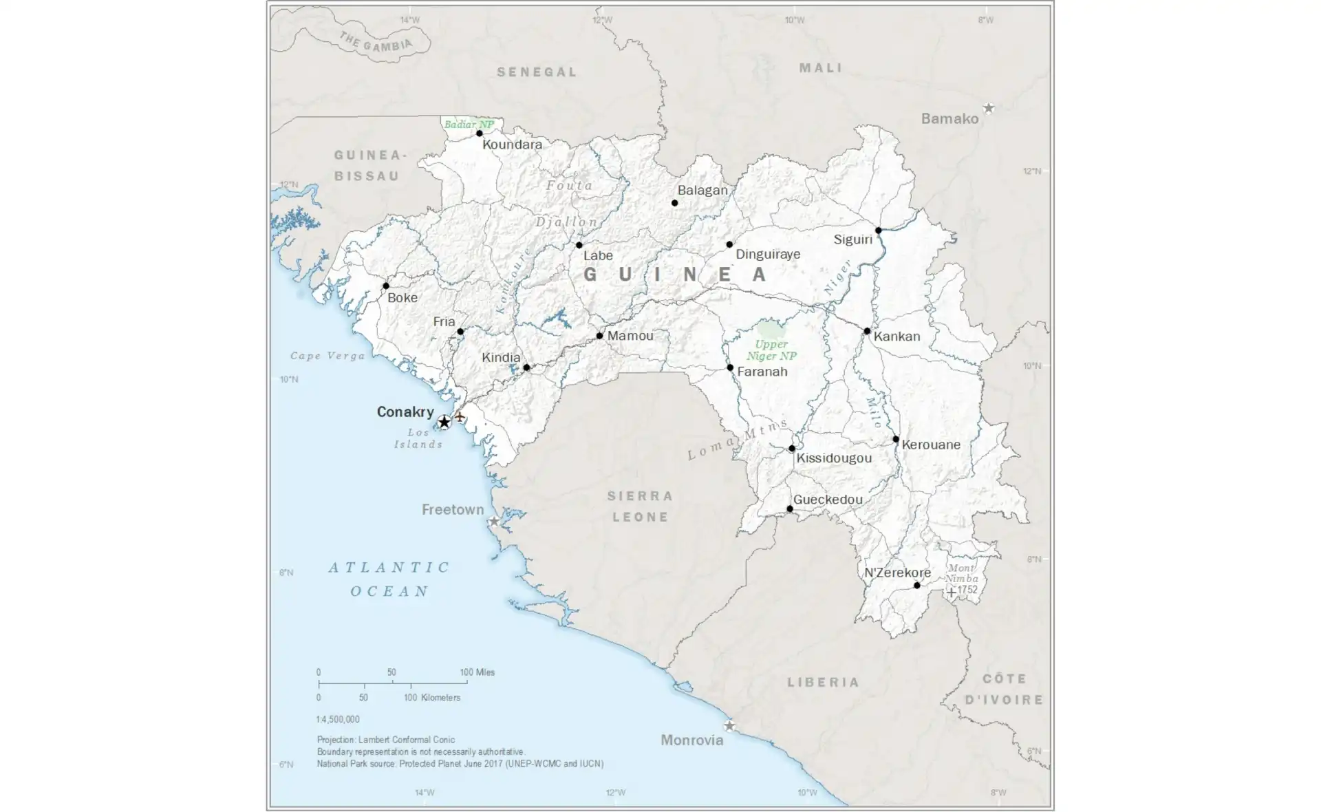
Guinea Facts at a Glance
| Official name | Republic of Guinea |
|---|---|
| Capital | Conakry |
| Largest city | Conakry |
| Region | West Africa |
| Population | About 15 million (2025 UN estimate) |
| Area | 245,857 km² (94,926 sq mi) – also called Guinea-Conakry to distinguish it from Guinea-Bissau |
| Coastline | About 320 km of Atlantic coastline |
| Official languages | French; Pular (Fula), Maninka and Susu are the main spoken languages |
| Currency | Guinean franc (GNF) |
| Government | Presidential republic under a constitution approved by referendum in 2025; the military had taken power in a 2021 coup |
| Independence | 2 October 1958, from France (the first French colony in sub-Saharan Africa to become independent) |
| Neighbouring countries | 6: Guinea-Bissau, Senegal, Mali, Côte d'Ivoire, Liberia, Sierra Leone |
| Administrative divisions | 8 regions (including the capital, Conakry), divided into 33 prefectures |
| Main cities | Conakry, Nzérékoré, Kankan, Kindia, Labé, Boké |
| Highest point | Mount Nimba, 1,752 m (5,748 ft), on the border with Côte d'Ivoire |
| Rivers and lakes | Sources of the Niger, Senegal (Bafing) and Gambia rivers in the Fouta Djallon highlands, earning Guinea the name "water tower of West Africa" |
| Climate | Tropical: very wet on the coast (Conakry gets over 3,500 mm of rain a year), with a rainy season from about May to October |
| Economy | Mining: Guinea has the world's largest bauxite reserves and is a top exporter; the Simandou iron-ore project and gold are also important |
| Time zone | UTC+0 (Greenwich Mean Time) |
| Calling code | +224 |
Population figures are rounded 2025 estimates from the UN World Population Prospects 2024 unless stated otherwise. Facts checked September 2026.
See also: Conakry city guide, countries of West Africa, French-speaking countries in Africa, African independence timeline.
Geography: From Coast to Highlands
Guinea's diverse geography encompasses 245,857 square kilometers divided into four distinct natural regions, each with unique characteristics that have shaped settlement patterns, economic activities, and cultural development. From the Atlantic coast to the forest highlands, Guinea's landscape transitions through coastal plains, mountain ranges, savannas, and dense forests, creating one of West Africa's most ecologically diverse nations.
The Maritime Guinea (Basse-Guinée) region stretches along the Atlantic coast, characterized by mangrove swamps, estuaries, and coastal plains that rarely exceed 50 meters in elevation. This region receives the heaviest rainfall in the country, often exceeding 4,000 millimeters annually in some areas. The capital Conakry occupies a peninsula jutting into the Atlantic, while numerous rivers create a deltaic landscape supporting rice cultivation and fishing. Offshore, the Los Islands provide scenic beauty and historical significance as former slave trading posts.
The Fouta Djallon highlands dominate Middle Guinea, rising to over 1,500 meters and forming the watershed for West Africa's major rivers. These sandstone plateaus, deeply incised by valleys and waterfalls, create a landscape of dramatic beauty. The cooler climate and reliable water sources have made this region a center of Fulani civilization for centuries. Mount Loura, reaching 1,515 meters, stands as one of the highest peaks, while the sources of the Niger, Senegal, and Gambia rivers originate from these highlands, earning Guinea its nickname as the "water tower of West Africa."
Upper Guinea encompasses vast savanna plains that extend toward Mali and Côte d'Ivoire, characterized by seasonal grasslands dotted with baobab and shea trees. This region experiences a pronounced dry season and supports extensive cattle herding alongside cultivation of millet, maize, and groundnuts. The Forest Region (Guinée Forestière) in the southeast contains the last remnants of the Upper Guinean forests, including the Mount Nimba Strict Nature Reserve, a UNESCO World Heritage site shared with Côte d'Ivoire, harboring exceptional biodiversity including endemic species found nowhere else on Earth.
Total Area
245,857 km²
Population
About 15 million
Natural Regions
4 distinct zones
Highest Peak
Mount Nimba (1,752m)
Mineral Wealth: Blessing and Curse
Guinea sits atop one of the world's richest concentrations of minerals, particularly bauxite, the primary ore for aluminum production. The country holds the world's largest bauxite reserves (roughly a quarter of the global total, according to the US Geological Survey). Major deposits in the Boké, Fria and Kindia areas have attracted international mining companies, and Guinea now rivals Australia as the world's largest bauxite producer while being by far the largest exporter, mostly to China. The distinctive red earth of bauxite mines dominates landscapes in mining regions.
Guinea's Mineral Resources
The country's geological wealth extends far beyond bauxite:
- Iron Ore - The Simandou range holds one of the world's largest high-grade iron ore deposits; after decades of delays it is being developed by Rio Tinto and Chinese-led partners, with a new railway of about 600 km to a port on the coast
- Gold - Significant deposits in the Upper Guinea region, with both industrial and artisanal mining operations
- Diamonds - Alluvial diamonds in the Forest Region, though production remains largely artisanal
- Uranium - Potential deposits identified but unexploited due to political and environmental concerns
- Nickel and Cobalt - Laterite deposits with potential for future development
Despite this mineral wealth, Guinea exemplifies the "resource curse" phenomenon. Mining provides the large majority of export earnings but employs only a small share of the workforce. Weak governance, corruption, and unfavorable contracts have limited benefits for ordinary Guineans. Environmental degradation from mining, including deforestation, water pollution, and displacement of communities, creates additional costs borne primarily by rural populations.
Historical Foundations
Guinea's history reaches back to great West African empires. The Mali Empire (13th-16th centuries), founded by Sundiata Keita in the upper Niger region on today's Guinea–Mali border, incorporated much of present-day Upper Guinea, establishing trade routes and Islamic influence that persist today. The Fouta Djallon emerged as a major Islamic state in the 18th century when Fulani Muslims established a theocratic confederation that became a center of Islamic learning and political power in West Africa.
European contact intensified from the 15th century as Portuguese, then French and British traders established coastal posts. The slave trade devastated populations, with the Los Islands and Rio Pongo serving as major embarkation points. French colonial expansion accelerated in the late 19th century, meeting fierce resistance from leaders like Samori Touré, who fought French forces for nearly two decades before his capture in 1898. Ahmed Sékou Touré, who claimed descent from him, would later lead Guinea to independence.
French colonial rule imposed forced labor, taxation, and cash crop production while neglecting education and development. The colony of French Guinea became part of French West Africa, with Conakry serving as a regional administrative center. Colonial policies favored coastal elites while marginalizing interior populations, creating regional disparities that persist. The colonial economy focused on extracting raw materials, establishing patterns of dependency that would prove difficult to break.
Independence and Isolation
Guinea made history on September 28, 1958, when it became the first French African colony to reject membership in the French Community, choosing immediate independence under the leadership of Ahmed Sékou Touré. The vote was overwhelming: 95% chose independence despite French threats to withdraw all assistance. France's vindictive response included removing equipment, burning documents, and ending all aid overnight, leaving the new nation to build from scratch.
Sékou Touré's rule (1958-1984) began with pan-African idealism but devolved into paranoid authoritarianism. His Democratic Party of Guinea (PDG) established a one-party state promoting "African socialism" while suppressing opposition. The regime's human rights abuses included the notorious Camp Boiro prison where thousands of political prisoners were tortured and killed. Paranoia about plots led to purges that decimated the educated class, with, by some estimates, up to 50,000 people killed and many more fleeing into exile.
Economic policies during this period proved disastrous. State control of the economy, collectivization attempts, and isolation from Western markets led to economic collapse. Guinea left the CFA franc zone in 1960 and issued its own currency (the syli from 1972 to 1985), which further isolated the economy. By Sékou Touré's death in 1984, Guinea ranked among the world's poorest nations despite its natural wealth. The military coup that brought Lansana Conté to power promised liberalization but delivered another form of authoritarian rule that lasted until his death in 2008, after which another military junta briefly took power.
Cultural Diversity
Guinea's population of about 15 million comprises more than 20 ethnic groups, each maintaining distinct languages, customs, and social organizations. The Fulani (Peul) represent about 33% of the population, concentrated in the Fouta Djallon highlands where they established a sophisticated Islamic civilization. Their pastoral traditions, hierarchical social structure, and emphasis on Islamic education have profoundly influenced Guinean culture. The Fulani language (Pular) serves as a lingua franca in much of the interior.
Mandinka People
Comprising about 30% of the population, the Mandinka (Malinké) dominate Upper Guinea's savanna regions. Descendants of the Mali Empire, they maintain strong oral traditions through griots who preserve history, genealogies, and cultural values through music and storytelling. Their society emphasizes age grades and initiation ceremonies.
Susu People
The Susu (20%) concentrate in coastal regions, historically serving as intermediaries in trade. Their culture blends Islamic practices with traditional beliefs, including powerful secret societies. Susu traders played crucial roles in regional commerce, and their language remains important in coastal areas and Conakry.
Forest Peoples
The Forest Region hosts diverse groups including Kissi, Toma, and Guerze peoples. These communities maintain animist traditions alongside Christianity and Islam, with masked dances and forest spirits playing important cultural roles. Their knowledge of forest resources includes sophisticated agricultural and medicinal practices.
Islam dominates religious life, practiced by approximately 85% of Guineans, though often blended with traditional beliefs. Christianity (8%) concentrates in urban areas and the Forest Region, while traditional religions persist, particularly in rural areas. Religious tolerance generally prevails, with interfaith marriages common and religious holidays celebrated across communities. Traditional practices like initiation ceremonies, ancestor veneration, and healing rituals continue alongside organized religions.
Regional Profiles
Conakry: Overcrowded Capital
Conakry is home to about 2 million people or more – roughly one in seven Guineans. The city sprawls along the Kaloum Peninsula and mainland suburbs, with inadequate infrastructure struggling to serve explosive growth. Colonial-era buildings in the city center contrast with sprawling informal settlements. The port handles most international trade, while markets like Madina provide vibrant commercial activity. Chronic electricity and water shortages, traffic congestion, and waste management challenges plague daily life.
Fouta Djallon: Highland Heart
This highland region centers on cities like Labé and Dalaba, maintaining distinct Fulani cultural identity. The cool climate supports dairy farming and fruit cultivation, including oranges that thrive in the highlands. Traditional architecture features round huts with conical thatched roofs adapted to heavy rainfall. Islamic scholarship flourishes in numerous Quranic schools. Tourism potential exists in waterfalls, hiking trails, and cultural experiences, though infrastructure remains limited. The region's conservative social structure contrasts with coastal areas.
Contemporary Challenges
Guinea's transition to democracy remains incomplete despite progress since 2010. The first democratic election brought Alpha Condé to power, raising hopes for change. However, his controversial third term in 2020, achieved through constitutional manipulation, sparked violent protests. The September 2021 military coup reflected widespread frustration with corruption and democratic backsliding. A new constitution was approved by referendum in September 2025, opening the way to elections to end the transition; critics argue the process mainly entrenched the military-led leadership.
Economic challenges persist despite mineral wealth. Around 40–45% of Guineans live below the national poverty line, with rural areas particularly disadvantaged, and youth underemployment drives urban migration. Infrastructure deficits include inadequate electricity (only about half the population has access), poor roads, and limited healthcare facilities. The education system struggles with overcrowded classrooms, undertrained teachers, and low completion rates, particularly for girls.
Corruption permeates all levels of society, from petty bribes to grand theft of mining revenues. Weak institutions, politicized justice systems, and lack of accountability enable systematic corruption. Environmental degradation accelerates through uncontrolled mining, deforestation for charcoal and agriculture, and urban expansion. Climate change brings irregular rainfall patterns, threatening agricultural livelihoods. Regional instability, including conflicts in neighboring countries, creates refugee flows and security concerns.
Economic Sectors
Agriculture employs most of the workforce but contributes a much smaller share of GDP, highlighting low productivity. Subsistence farming dominates, with rice as the staple crop supplemented by cassava, maize, and groundnuts. Cash crops include coffee, cocoa, palm oil, and fruits, though poor infrastructure limits market access. The livestock sector, particularly important in the Fouta Djallon, faces challenges from disease and limited veterinary services.
The service sector, concentrated in Conakry, includes telecommunications, banking, and informal trade. Mobile phone penetration exceeds 100%, enabling mobile banking and improving rural connectivity. The informal sector dominates urban employment, with petty trade, transportation, and services providing survival livelihoods. Tourism remains underdeveloped despite significant potential in ecotourism, cultural tourism, and adventure travel.
Manufacturing remains minimal, limited to beverage production, food processing, and construction materials. The lack of reliable electricity, skilled workers, and supporting infrastructure constrains industrial development. Artisanal production includes textiles, leather goods, and crafts, though mostly for local consumption. Value addition to raw materials remains a missed opportunity, with bauxite exported unprocessed and agricultural products sold fresh rather than processed.
Population Distribution and Density
Guinea's population of about 15 million is distributed unevenly across its four natural regions, with density patterns reflecting geographic constraints, economic opportunities, and historical settlement patterns. Greater Conakry is by far the most densely populated area, while vast areas of the interior highlands and savannas maintain much lower densities.
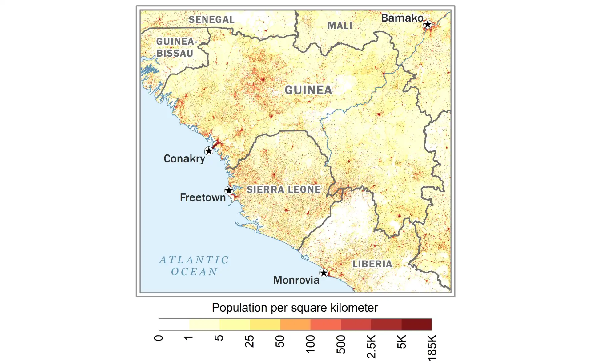
The Fouta Djallon highlands show moderate population density concentrated in valleys and around towns like Labé and Mamou, where the cooler climate and water availability support settled agriculture. Upper Guinea's savannas have lower density, with populations clustered around market towns and along rivers. The Forest Region shows varied density - high around N'zérékoré and other towns but very low in protected forest areas. Rural-to-urban migration continues to concentrate population in Conakry, which holds about one in seven Guineans despite infrastructure constraints.
International Relations
Guinea maintains complex relationships with neighboring states, balancing regional cooperation with sovereignty concerns. The Mano River Union, including Sierra Leone, Liberia, and Côte d'Ivoire, promotes economic integration despite historical conflicts. Border disputes occasionally flare, particularly in resource-rich areas. Guinea hosts refugees from regional conflicts while its own citizens migrate for economic opportunities. ECOWAS membership provides frameworks for cooperation, though Guinea was suspended from ECOWAS after the 2021 coup.
China has emerged as a major partner, investing billions in infrastructure projects in exchange for mining concessions. The relationship includes the construction of roads, dams, and government buildings, though concerns about debt sustainability and labor practices persist. Traditional partners like France maintain economic interests despite political tensions. Russia seeks expanded influence through military cooperation and mining investments. The United States provides development assistance while pressing for democratic reforms.
International mining companies dominate the extractive sector, with complex relationships involving revenue sharing, environmental responsibilities, and community relations. Companies from Australia, China, Russia, and other nations compete for concessions, sometimes fueling corruption. International financial institutions provide loans and grants tied to governance reforms, with mixed results. The diaspora, particularly in France and the United States, provides remittances and maintains political engagement.
Future Prospects
Guinea's future hinges on breaking the resource curse through better governance and economic diversification. The Simandou iron ore project, with its new railway and port, could transform public finances if revenues are managed transparently. Agricultural modernization could improve food security and create employment if supported by infrastructure development and market access. The country's water resources offer hydroelectric potential to address energy deficits.
Democratic consolidation remains crucial for stability and development. The end of the post-2021 transition is a test of whether institutions can become independent of the military. Youth engagement in politics and civil society offers hope for change, but requires space for participation and economic opportunities. Regional integration could expand markets and promote stability if political will exists. Education reform, particularly in technical and vocational training, could address skills gaps.
Ultimately, Guinea's vast natural wealth could support broad-based development if managed transparently and sustainably. The young population, with median age around 19, represents both a challenge requiring job creation and an opportunity for transformation. Success requires breaking cycles of authoritarian rule, corruption, and resource exploitation that have impoverished a naturally wealthy nation. Whether Guinea can finally translate its position as West Africa's water tower and mineral giant into prosperity for its people remains the central question for this pivotal African nation.
Guinea: Frequently Asked Questions
What is the capital of Guinea?
The capital of Guinea is Conakry.
What is the population of Guinea?
Guinea has about 15 million people (2025 UN estimate). The largest city is Conakry.
How big is Guinea?
Guinea covers 245,857 km² (94,926 sq mi), also called Guinea-Conakry to distinguish it from Guinea-Bissau.
What language is spoken in Guinea and what is its currency?
Official languages: French; Pular (Fula), Maninka and Susu are the main spoken languages. Currency: Guinean franc (GNF).
Which countries border Guinea?
Guinea borders Guinea-Bissau, Senegal, Mali, Côte d'Ivoire, Liberia and Sierra Leone.
When did Guinea become independent?
Guinea became independent on 2 October 1958 from France (the first French colony in sub-Saharan Africa to become independent).