Djibouti: Strategic Gateway Between Africa and Arabia
Djibouti is a small country in the Horn of Africa, on the Bab-el-Mandeb Strait where the Red Sea meets the Gulf of Aden. It covers 23,200 km², its capital is Djibouti City, and it has about 1.2 million people (2025 UN estimate). French and Arabic are official. Djibouti borders Eritrea, Ethiopia and Somalia, became independent from France on 27 June 1977, and contains Lake Assal, the lowest point in Africa.
The Republic of Djibouti occupies one of the world's most strategic locations at the southern entrance to the Red Sea, where the Gulf of Aden meets the Bab-el-Mandeb strait. This small but vital nation serves as a crucial maritime hub, hosting military bases from multiple world powers while maintaining its position as the primary port for landlocked Ethiopia. With unique geological wonders and a multicultural society, Djibouti bridges continents and oceans.
Djibouti Map
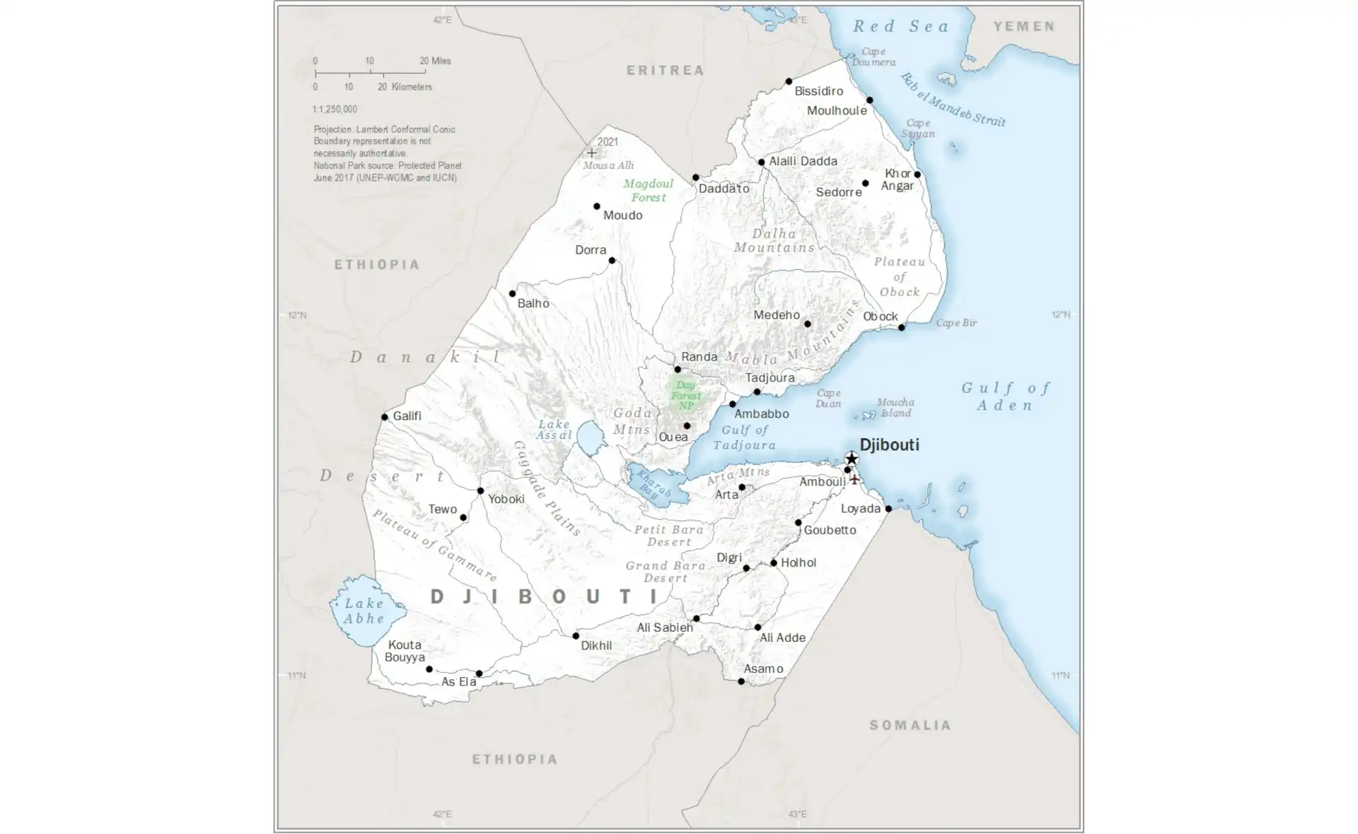
Djibouti Facts at a Glance
| Official name | Republic of Djibouti |
|---|---|
| Capital | Djibouti City |
| Largest city | Djibouti City (home to more than half the population) |
| Region | East Africa |
| Population | About 1.2 million (2025 UN estimate) |
| Area | 23,200 km² (8,958 sq mi) – on the Bab-el-Mandeb Strait between the Red Sea and the Gulf of Aden |
| Coastline | Coastline of about 314 km on the Gulf of Tadjoura, Gulf of Aden and Red Sea |
| Official languages | French and Arabic; Somali and Afar are the main spoken languages |
| Currency | Djiboutian franc (DJF), pegged to the US dollar |
| Government | Presidential republic |
| Independence | 27 June 1977, from France (formerly French Somaliland, then the French Territory of the Afars and the Issas) |
| Neighbouring countries | 3: Eritrea, Ethiopia, Somalia. The border with Somalia is with the self-declared Republic of Somaliland. |
| Administrative divisions | 5 regions plus the city of Djibouti |
| Main cities | Djibouti City, Ali Sabieh, Tadjourah, Dikhil, Obock, Arta |
| Highest point | Moussa Ali, 2,028 m (6,654 ft), on the Eritrea–Ethiopia tripoint |
| Rivers and lakes | No permanent rivers; Lake Assal (155 m below sea level, the lowest point in Africa) and Lake Abbe |
| Climate | Hot desert: summer highs often above 40°C, very little rain; slightly cooler from November to March |
| Economy | Port and logistics services (the main outlet for landlocked Ethiopia via the Addis Ababa–Djibouti railway), foreign military bases and telecoms |
| Time zone | UTC+3 (East Africa Time) |
| Calling code | +253 |
Population figures are rounded 2025 estimates from the UN World Population Prospects 2024 unless stated otherwise. Facts checked September 2026.
See also: Djibouti City city guide, countries of East Africa, Horn of Africa map, French-speaking countries in Africa, Arabic-speaking countries in Africa, African independence timeline.
Population Distribution and Density
Djibouti's population of about 1.2 million people (2025 UN estimate) is highly urbanised, with more than two-thirds living in the capital, Djibouti City. This makes it one of Africa's most urbanized countries, as the harsh desert climate and limited arable land restrict settlement to coastal areas and oases where water and economic opportunities are available.
Population Density Map
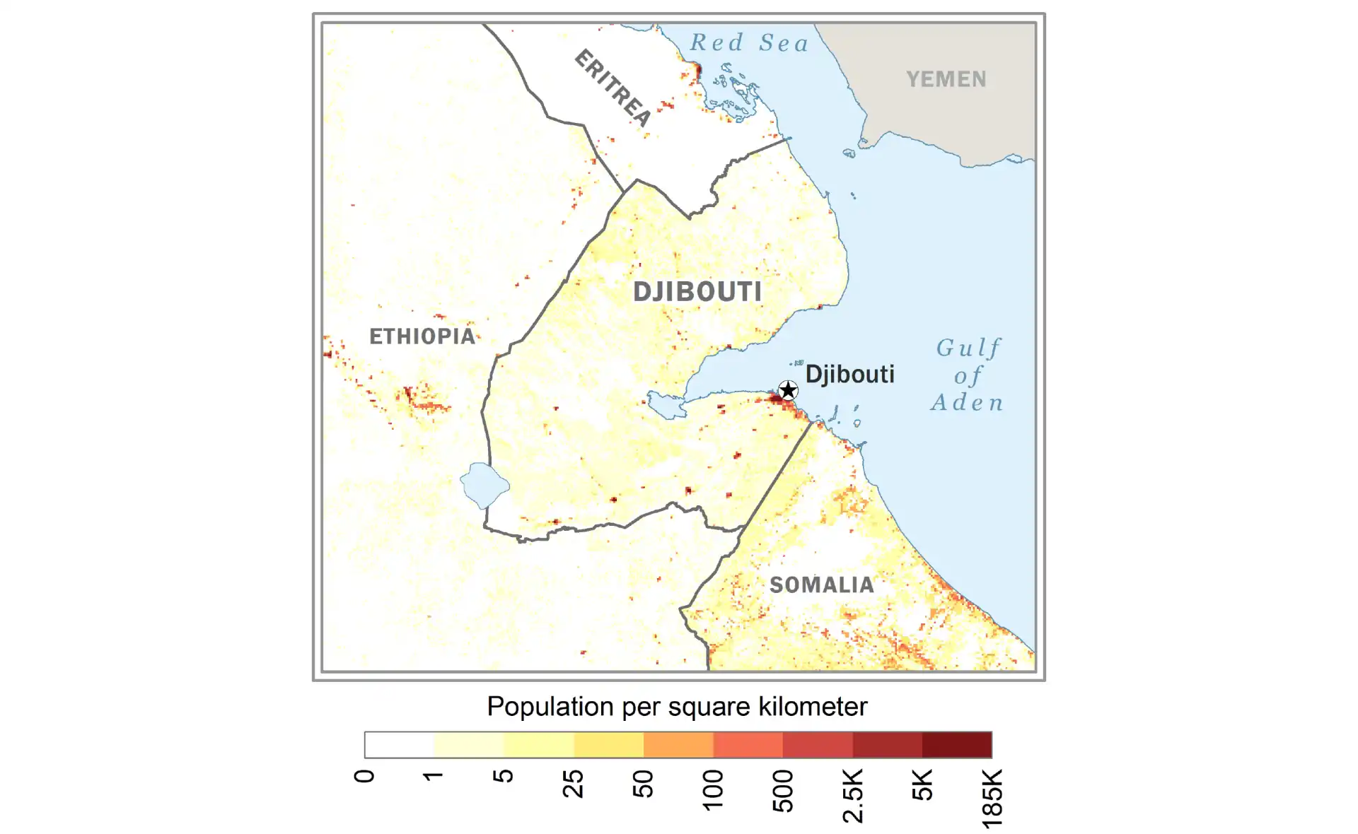
The concentration of population in Djibouti City reflects the country's role as a maritime gateway and service economy. The port city offers employment opportunities in logistics, trade, and international services, while the interior remains largely pastoral with scattered nomadic communities who follow traditional migration patterns between seasonal grazing areas.
Djibouti City
Home to the large majority of the population, serving as the economic and administrative center.
Coastal Towns
Small population centers like Tadjoura and Obock along the coast, supporting fishing and trade activities.
Interior Regions
Very low density with nomadic pastoralist communities moving between wells and grazing areas in the desert interior.
Strategic Location and Geography
Djibouti's location at the Bab-el-Mandeb strait, meaning "Gate of Tears" in Arabic, places it at one of the world's busiest shipping chokepoints. Before attacks on Red Sea shipping began in late 2023 diverted many vessels, roughly 10–12% of world trade passed through these waters, making Djibouti's 314-kilometer coastline disproportionately important to international trade. The country covers 23,200 square kilometers, roughly the size of New Jersey, but its strategic value far exceeds its modest dimensions.
The landscape presents a dramatic tapestry of geological extremes. The country sits at the triple junction where three tectonic plates - the Arabian, African, and Somali plates - are pulling apart, creating the Afar Triangle, one of the most geologically active regions on Earth. This rifting process, which will eventually split the Horn of Africa from the mainland and create a new ocean, makes Djibouti a living laboratory for studying continental breakup and seafloor spreading.
Djibouti's terrain encompasses coastal plains, mountain ranges, and the remarkable Afar Depression. The Gulf of Tadjoura cuts deep into the country's heart, creating a natural harbor that has attracted seafarers for millennia. Inland, the landscape rises to volcanic plateaus and mountain ranges, with Moussa Ali reaching 2,028 meters on the Ethiopian border. The western regions feature the extraordinary Lake Assal, Africa's lowest point at 155 meters below sea level and one of the saltiest bodies of water on Earth, with salinity levels exceeding 34% - ten times saltier than the ocean.
Total Area
23,200 km²
Coastline
314 km
Lowest Point
Lake Assal (-155m)
Highest Peak
Moussa Ali (2,028m)
Climate and Extreme Environment
Djibouti experiences one of the world's hottest climates, Djibouti City is among the hottest capital cities in the world, with an average annual temperature of about 30°C (86°F). The country endures two main seasons: a relatively cool period from October to April when temperatures "drop" to around 25-30°C, and a scorching hot season from May to September when temperatures regularly exceed 45°C (113°F), particularly in the interior lowlands.
Rainfall remains scarce and erratic, averaging less than 130 millimeters annually in most areas. The coastal regions receive slightly more precipitation than the interior, though "more" remains relative in this arid land. On the coast most rain falls between October and April, while the interior gets brief summer storms; either way it often comes as torrential downpours that cause flash floods in the wadis (dry riverbeds), temporarily transforming the parched landscape before the water quickly evaporates or seeps away.
The extreme climate has shaped unique ecosystems adapted to harsh conditions. Despite the aridity, Djibouti supports surprising biodiversity in specialized niches. The Day Forest National Park on the Goda Mountains represents a remnant of ancient juniper forests, creating a cool, misty refuge that contrasts dramatically with the surrounding desert. Coastal mangroves at Musha and Maskali islands provide critical habitat for marine life, while the coral reefs of the Seven Brothers Islands harbor exceptional marine biodiversity in the confluence of the Red Sea and Indian Ocean.
Geological Wonders
Djibouti's position in the Afar Triangle makes it one of the most geologically fascinating places on Earth. The ongoing separation of tectonic plates has created a landscape of volcanic formations, hot springs, and salt formations that attract geologists from around the world. The Ardoukoba volcano, which last erupted in 1978, represents the most recent addition to Djibouti's volcanic inventory, while numerous dormant cones and lava fields testify to millions of years of volcanic activity.
Lake Assal
This hypersaline lake lies in a rift basin 155 meters below sea level, making it Africa's lowest point. The lake's extreme salinity creates stunning white salt formations along its shores, while local Afar people have harvested salt here for centuries, maintaining traditional camel caravans to transport this "white gold" to Ethiopian markets.
Lake Abbe
Straddling the Ethiopia-Djibouti border, this alkaline lake features otherworldly limestone chimneys up to 50 meters high, formed by hot springs. The surreal landscape, often shrouded in steam, served as a filming location for "Planet of the Apes" and supports large colonies of flamingos during certain seasons.
Ghoubbet al-Kharab
Known as the "Devil's Cauldron," this inlet of the Gulf of Tadjoura sits directly above the junction of tectonic plates. Local legends speak of demons pulling fishermen to the depths, likely inspired by the powerful currents and underwater volcanic activity that make these waters particularly treacherous.
Historical Crossroads
Djibouti's strategic location has attracted traders, conquerors, and empires throughout history. Ancient Egyptian expeditions to the "Land of Punt" likely passed through these waters, while Greek and Roman texts describe the region as part of the prosperous trade routes connecting the Mediterranean with India and the Far East. The indigenous Afar and Issa peoples have inhabited the region for millennia, developing nomadic lifestyles perfectly adapted to the harsh environment.
Islamic influence arrived early, with Arab traders establishing coastal settlements by the 9th century. The region became integrated into various Islamic sultanates, including the Sultanate of Adal and later the Ottoman Empire, which claimed nominal sovereignty over the coast. These Islamic states engaged in complex relationships with the Christian Ethiopian Empire inland, with Djibouti's ports serving as crucial gateways for trade and occasional military campaigns.
French colonial interest began in 1862 when France acquired the port of Obock, seeking a foothold on the sea route to the Indian Ocean; after the Suez Canal opened in 1869 the coast became a valuable coaling stop on the way to French Indochina. The French established Djibouti City in 1888, developing it as the capital of French Somaliland. The construction of the Franco-Ethiopian Railway from 1897 to 1917 transformed Djibouti into Ethiopia's primary outlet to the sea, a role it maintains today. Independence came peacefully on June 27, 1977, making Djibouti one of Africa's last territories to gain sovereignty.
The Port Economy
Djibouti's economy revolves around its strategic location and modern port facilities. Djibouti's ports handle roughly 90% of Ethiopia's foreign trade, serving a landlocked neighbour of about 135 million people. Port capacity has grown with the Doraleh Container Terminal (opened 2009 and taken under state control in 2018 after a dispute with DP World), the Chinese-financed Doraleh Multipurpose Port (2017) and a dedicated livestock port at Damerjog.
Strategic Maritime Assets
Djibouti has leveraged its location to become a regional maritime hub through several key developments:
- Free Trade Zones - Multiple zones offer tax incentives and streamlined procedures for international businesses
- Ship Services - Bunkering, repairs, and supplies for vessels transiting the Red Sea
- Transshipment Hub - Connecting Asian, European, and African shipping routes
- Digital Infrastructure - Submarine cable landing points making Djibouti a regional internet hub
- Logistics Networks - Road and rail connections to Ethiopia and beyond
The service sector, particularly port operations, logistics, and banking, contributes over 80% of GDP. Djibouti has positioned itself as a regional financial centre, helped by a currency pegged to the US dollar since 1949. The Addis Ababa–Djibouti Railway, a Chinese-built electrified line that opened in 2016–2018 and replaced the colonial-era track, has further strengthened economic ties and increased cargo capacity between the two nations.
Military Significance
Djibouti hosts one of the highest concentrations of foreign military bases in the world, earning substantial rental income while balancing complex international relationships. The American Camp Lemonnier, the only permanent US military base in Africa, serves as headquarters for counter-terrorism operations across the region. France keeps around 1,500 troops there, now its largest military presence in Africa, continuing historical ties while supporting regional stability operations.
China's first overseas military base, established in 2017, marks Beijing's growing strategic interests in protecting shipping lanes and investments. Japan's first overseas base since World War II focuses on anti-piracy operations, while Italy has its own base and other European forces use facilities there. This unique concentration of international forces creates an unusual dynamic where potential rivals maintain bases within kilometers of each other, all contributing to Djibouti's economy while pursuing their strategic interests.
The military presence brings both opportunities and challenges. Base leases provide substantial government revenue, while foreign troops support local businesses and employment. However, the military concentration also raises sovereignty concerns and complicates Djibouti's diplomatic balancing act. The government has skillfully maintained neutrality while maximizing economic benefits, though managing competing international interests requires constant diplomatic finesse.
Society and Culture
Djibouti's population of about 1.2 million comprises two main ethnic groups: the Issa Somali (60%) and the Afar (35%), with smaller Arab, Ethiopian, and European communities. This ethnic divide roughly corresponds to geographic distribution, with the Issa predominating in the capital and southern regions while the Afar inhabit the northern and western areas. Both groups maintain strong cultural identities while sharing Islamic faith and nomadic heritage.
Islam shapes daily life, with 94% of the population following Sunni Islam. The call to prayer punctuates the day, while Islamic holidays and customs influence social interactions. However, Djibouti maintains a relatively liberal interpretation of Islam, with women enjoying greater freedoms than in some neighboring countries. Traditional practices persist alongside Islamic customs, particularly among nomadic populations who maintain age-old traditions of camel herding, oral poetry, and customary law.
Language reflects colonial history and regional connections. French and Arabic serve as official languages, used in government and education. However, Somali and Afar remain the primary spoken languages, with most Djiboutians being multilingual. The capital's cosmopolitan character adds English, Ethiopian languages, and Hindi to the linguistic mix, creating a polyglot environment that facilitates international business and diplomacy.
Urban Concentration
Djibouti City dominates national life, housing more than two-thirds of the country's population. The capital combines colonial-era architecture with modern developments, creating a unique urban landscape. The old quarter retains French colonial buildings with shuttered windows and wrought-iron balconies, while new districts feature glass towers and Chinese-built infrastructure. The central market buzzes with activity as traders from across the region converge to exchange goods ranging from Ethiopian coffee to Yemeni honey.
The port district drives the urban economy, with constant activity as ships discharge containers, trucks queue for Ethiopian cargo, and workers service the maritime industry. Nearby, the financial district hosts banks and businesses serving the free trade zones, while diplomatic quarters accommodate embassies and international organizations drawn by Djibouti's strategic importance. The city's growth strains infrastructure, with informal settlements expanding as rural populations seek urban opportunities.
Secondary towns remain small but serve important functions. Ali Sabieh, near the Ethiopian border, acts as a commercial hub for cross-border trade. Tadjoura, one of the oldest settlements, maintains traditional architecture and serves the northern regions. Obock, the first French foothold, has declined in importance but retains historical significance. These smaller centers struggle with limited services and opportunities, contributing to continued rural-urban migration.
Development Challenges
Despite strategic advantages, Djibouti faces significant development challenges. The harsh climate limits agriculture to less than 1% of land area, forcing the country to import 90% of its food. Water scarcity poses a critical challenge, with most freshwater coming from underground aquifers increasingly strained by population growth and climate change. Desalination plants provide some relief but remain energy-intensive and expensive.
Unemployment, particularly among youth, remains persistently high despite economic growth. The modern port sector requires skilled workers, while many Djiboutians lack necessary training. Education systems struggle with limited resources, overcrowded classrooms, and high dropout rates. The nomadic lifestyle of many Afar and Issa communities complicates education delivery, though mobile schools and distance learning programs show promise.
Economic inequality has widened as port development creates wealth concentrated among elites and foreign investors. Living costs in Djibouti City rank among Africa's highest, driven by imports and international presence, while rural populations remain largely excluded from economic growth. The government's Vision 2035 development plan aims to address these disparities through economic diversification, improved education, and infrastructure development, though implementation faces financial and capacity constraints.
Regional Relations
Djibouti's relationships with neighbors reflect historical ties, economic interdependence, and strategic calculations. The Ethiopia connection remains paramount, with Djibouti serving as Ethiopia's maritime lifeline. The two countries share strong economic ties, with Ethiopia providing electricity to Djibouti while depending on Djiboutian ports. Djibouti carefully avoids involvement in Ethiopia's internal conflicts, and watches Ethiopia's search for alternative sea access, including via Somaliland, closely.
Relations with Eritrea thawed after the 2018 Ethiopia–Eritrea peace agreement, but the border dispute at Ras Doumeira, where the two armies clashed in 2008, has not been formally settled. Somalia relations remain complex, with ethnic Issa connections balanced against political instability across the border. Djibouti hosts Somali refugees while participating in African Union peacekeeping efforts in Somalia.
Within the Arab world, Djibouti maintains membership in the Arab League while balancing relationships with Saudi Arabia, the UAE, and Qatar despite Gulf rivalries. The government has avoided taking sides in regional disputes, maintaining its ports open to all while maximizing economic benefits. This diplomatic balancing act, essential for a small state among larger powers, has generally succeeded in maintaining stability and attracting investment.
Environmental Concerns
Climate change poses existential threats to Djibouti's fragile environment. Rising temperatures exacerbate already extreme heat, while changing precipitation patterns threaten water supplies. Sea level rise endangers coastal infrastructure including the vital ports, while coral bleaching damages marine ecosystems that support fisheries and tourism potential. The government has initiated adaptation measures including coastal defenses and water conservation, though resources remain limited.
Overgrazing by growing livestock herds degrades limited pastures, contributing to desertification and conflicts over resources. Traditional grazing patterns struggle to adapt to reduced rainfall and restricted movement due to development and borders. Marine resources face pressure from overfishing, pollution from shipping, and illegal fishing by foreign vessels. Conservation efforts include marine protected areas around the Seven Brothers Islands, though enforcement remains challenging.
Urban environmental challenges include waste management, air pollution from port activities, and inadequate sanitation in informal settlements. Rapid urbanization outpaces infrastructure development, creating health risks and environmental degradation. International support for environmental programs provides some assistance, but sustainable solutions require significant investment and behavioral changes in resource use.
Future Prospects
Djibouti's future hinges on successfully leveraging its strategic location while addressing internal development challenges. The Vision 2035 plan envisions transformation into a middle-income country through economic diversification, regional integration, and human capital development. Key projects include expanding port capacity, developing tourism around unique geological sites, and establishing Djibouti as a regional hub for finance, logistics, and digital services.
Geothermal energy potential offers hope for energy independence and industrial development. The volcanic geology that creates Djibouti's dramatic landscapes also provides steam that could generate electricity for domestic use and export. Initial exploration shows promising results, with potential to transform Djibouti from energy importer to exporter while supporting desalination plants to address water scarcity.
Success requires careful navigation of geopolitical complexities, sustainable management of natural resources, and inclusive development that benefits all citizens. The concentration of foreign military bases provides current stability and income but creates dependencies that could prove vulnerable to changing international dynamics. Developing human capital, strengthening institutions, and maintaining diplomatic flexibility will determine whether Djibouti can translate its strategic advantages into sustainable prosperity for its people. The small nation's ability to punch above its weight in regional affairs suggests potential for continued relevance in an evolving global landscape.
Port Infrastructure
Doraleh Container Terminal - 1.6 million TEU capacity
Doraleh Multipurpose Port - Bulk and general cargo
Damerjog Livestock Port - Live animal exports to the Gulf
Oil Terminal - Strategic fuel storage and distribution
Free Trade Zone - 48 square kilometers development
International Connections
Ethiopia-Djibouti Railway - 756km electrified line
Multiple submarine cables - Regional internet hub
International airport - Regional passenger and cargo hub
Road networks - Connecting to Ethiopia, Somaliland
Pipeline projects - Planned oil and gas infrastructure
Djibouti: Frequently Asked Questions
What is the capital of Djibouti?
The capital of Djibouti is Djibouti City.
What is the population of Djibouti?
Djibouti has about 1.2 million people (2025 UN estimate). The largest city is Djibouti City (home to more than half the population).
How big is Djibouti?
Djibouti covers 23,200 km² (8,958 sq mi), on the Bab-el-Mandeb Strait between the Red Sea and the Gulf of Aden.
What language is spoken in Djibouti and what is its currency?
Official languages: French and Arabic; Somali and Afar are the main spoken languages. Currency: Djiboutian franc (DJF), pegged to the US dollar.
Which countries border Djibouti?
Djibouti borders Eritrea, Ethiopia and Somalia. The border with Somalia is with the self-declared Republic of Somaliland.
When did Djibouti become independent?
Djibouti became independent on 27 June 1977 from France (formerly French Somaliland, then the French Territory of the Afars and the Issas).