Equatorial Guinea: Africa's Spanish Island
Equatorial Guinea is a small Central African country on the Gulf of Guinea, made up of a mainland region (Río Muni) and islands including Bioko and Annobón. Its capital is Malabo on Bioko Island, while Bata on the mainland is the largest city. It covers 28,051 km², has about 1.9 million people (2025 UN estimate), and is the only African country with Spanish as an official language. It borders Cameroon and Gabon and became independent from Spain on 12 October 1968.
The Republic of Equatorial Guinea stands as Africa's only Spanish-speaking nation, a unique legacy of colonial history in a continent dominated by English, French, and Portuguese linguistic influences. This small country comprises a mainland region (Río Muni) and several islands, including Bioko Island where the capital Malabo sits. Since the discovery of vast oil reserves in the 1990s, Equatorial Guinea went from one of Africa's poorest nations to having, at the peak of the oil boom, one of the highest GDPs per head in Africa, though this wealth remains highly concentrated.
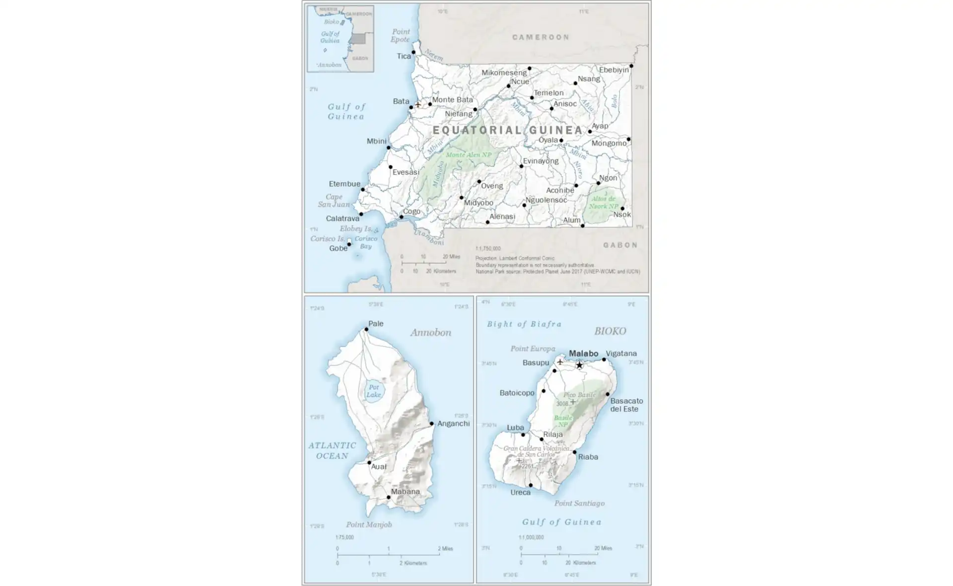
Equatorial Guinea Facts at a Glance
| Official name | Republic of Equatorial Guinea |
|---|---|
| Capital | Malabo; Ciudad de la Paz on the mainland is being built as a future capital |
| Largest city | Bata |
| Region | Central Africa |
| Population | About 1.9 million (2025 UN estimate) |
| Area | 28,051 km² (10,831 sq mi) – made up of the mainland region Río Muni plus Bioko, Annobón and smaller islands |
| Coastline | About 296 km of coastline on the Gulf of Guinea |
| Official languages | Spanish, French and Portuguese; Fang and Bubi are widely spoken |
| Currency | Central African CFA franc (XAF) |
| Government | Presidential republic, dominated by one party |
| Independence | 12 October 1968, from Spain |
| Neighbouring countries | 2: Cameroon, Gabon. Bioko Island lies about 40 km off the coast of Cameroon. |
| Administrative divisions | 8 provinces (3 on the islands, 5 on the mainland) |
| Main cities | Bata, Malabo, Ebebiyín, Mongomo, Luba |
| Highest point | Pico Basilé, about 3,010 m (9,875 ft), on Bioko |
| Rivers and lakes | Mbini (Benito) River; the Ntem and Muni estuary form parts of the mainland borders |
| Climate | Equatorial: hot and humid all year, very rainy on Bioko |
| Economy | Oil and natural gas provide most export earnings, though output has been declining; high GDP per head but wide poverty |
| Time zone | UTC+1 (West Africa Time) |
| Calling code | +240 |
Population figures are rounded 2025 estimates from the UN World Population Prospects 2024 unless stated otherwise. Facts checked September 2026.
See also: Malabo city guide, countries of Central Africa, French-speaking countries in Africa, Portuguese-speaking countries in Africa, African independence timeline.
Unique Geography: Islands and Mainland
Equatorial Guinea's territory of 28,051 square kilometers splits between the continental region of Río Muni (26,017 km²) and several islands totaling 2,034 km². This unusual configuration resulted from colonial negotiations that left Spain with disconnected territories. Río Muni, wedged between Cameroon and Gabon, contains about 93% of the country's land area and most of its population. Dense tropical rainforest covers most of this mainland region, though deforestation for agriculture and logging has accelerated in recent decades.
Bioko Island, formerly known as Fernando Pó, lies 40 kilometers off the Cameroon coast in the Gulf of Guinea. Volcanic in origin, the island rises dramatically from the sea to Pico Basilé at about 3,010 meters, the country's highest point. This elevation creates distinct climate zones from coastal mangroves through montane forests to subalpine meadows near the summit. The island's isolation has fostered unique biodiversity, including endemic primates and birds found nowhere else on Earth.
Annobón Island, the country's most remote territory, lies far out in the Gulf of Guinea, south-west of São Tomé and south of the equator despite the country's name. This small volcanic island of just 17 km² supports about 5,000 inhabitants who maintain distinct cultural traditions. Corisco, Elobey Grande, and Elobey Chico are smaller islands near the mainland coast, historically important for trade but now sparsely populated. This geographic fragmentation creates significant administrative and development challenges while contributing to cultural diversity.
Total Area
28,051 km²
Islands
5 main islands
Highest Peak
Pico Basilé (~3,010m)
Population
~1.9 million
From Poverty to Petroleum
The discovery of oil and gas reserves in the 1990s fundamentally transformed Equatorial Guinea's economy and society. Before oil, the country ranked among the world's poorest, dependent on cocoa and timber exports. The Zafiro field discovery in 1995 initiated an oil boom in which GDP multiplied many times over within little more than a decade, one of the fastest growth spurts ever recorded. Oil and gas still provide the large majority of export earnings and government revenue and has funded massive infrastructure projects.
The Oil Economy Impact
Petroleum wealth has brought dramatic changes to Equatorial Guinea:
- Infrastructure Boom - New airports, highways, ports, and entire cities built from oil revenues
- Ciudad de la Paz - A planned new capital (formerly called Oyala) in the mainland interior, still under construction; Malabo remains the capital
- Income Inequality - Despite high per capita GDP, most citizens remain poor while elites accumulate vast wealth
- Dutch Disease - Oil dependence has weakened other economic sectors like agriculture
International oil companies, historically US firms such as ExxonMobil, Hess and Marathon Oil (now part of ConocoPhillips), have operated the main fields under production-sharing agreements. The government's national oil company, GEPetrol, participates in ventures but lacks independent operational capacity. Natural gas production has grown significantly, with a major liquefied natural gas plant on Bioko Island exporting to global markets. However, declining oil reserves and volatile prices threaten the sustainability of this economic model.
Colonial Legacy and Independence
Spanish colonization began in 1778 when Portugal ceded Fernando Pó and Annobón to Spain in exchange for territory in South America. However, Spanish control remained minimal until the 19th century, with British merchants and missionaries dominating Bioko Island's economy and society. The British even used Fernando Pó as a base for anti-slavery patrols, establishing Clarence City (now Malabo) in 1827. Spanish authority gradually strengthened, particularly after losing most American colonies.
The colonial economy relied on plantation agriculture, particularly cocoa cultivation on Bioko Island. Labor shortages led to the importation of workers from other African colonies, including Nigerians, Cameroonians, and Liberians, creating the ethnically diverse Fernandino community. Spanish Guinea, as the colony was known, remained relatively isolated from anti-colonial movements sweeping Africa. Spain's fascist government under Franco showed little interest in preparing the colony for independence.
Independence came suddenly on October 12, 1968, with Francisco Macías Nguema becoming the first president. His rule quickly devolved into one of Africa's most brutal dictatorships, earning him comparisons to Pol Pot. Macías renamed Bioko Island after himself, banned Christianity, and implemented policies that killed or drove into exile up to one-third of the population. His nephew, Teodoro Obiang Nguema Mbasogo, overthrew him in 1979, beginning one of the longest rules of any leader in the world.
Cultural Mosaic
Equatorial Guinea's population of about 1.9 million (2025 UN estimate) comprises several distinct ethnic groups shaped by geography and history. The Fang people make up about 85% of the national population and have dominated politics since independence. Traditionally organized in clans with egalitarian structures, the Fang maintain strong cultural traditions including the ritualistic use of iboga and elaborate wooden sculptures. Their language, though sharing roots with other Bantu languages, has incorporated Spanish vocabulary.
Bubi People
Indigenous to Bioko Island, the Bubi maintained an isolated kingdom until Spanish colonization. Their matrilineal society and unique language distinguish them from mainland groups. Despite comprising only 6% of the national population, Bubi culture significantly influences island life through traditional festivals and spiritual practices.
Fernandinos
Descendants of freed slaves and colonial-era immigrants form a Creole community in Malabo. Speaking Pichinglis (a form of Pidgin English) alongside Spanish, they historically dominated commerce and administration. Their Anglo-African culture adds another layer to national diversity.
Annobonese
The remote Annobón Island population speaks Fá d'Ambô, a Portuguese-based creole despite Spanish rule. Their isolation preserved unique traditions including specific fishing techniques and cultural festivals. Integration with the mainland remains limited due to distance and linguistic differences.
Spanish colonial influence created a unique linguistic landscape in Africa. While Spanish serves as the official language, most Equatoguineans speak indigenous languages at home. French (1998) and Portuguese (2010) were added as official languages for regional integration. The persistence of multiple languages reflects the country's complex identity straddling Hispanic, African, and global influences.
Island Profiles
Bioko Island
The volcanic island hosts the capital Malabo and most oil infrastructure. Pristine beaches line the coast while virgin rainforest covers mountain slopes. The island is home to seven monkey species, several of them unique to Bioko or the nearby mainland, making it a priority for conservation. Colonial architecture in Malabo contrasts with modern oil-funded construction. Luba, the second-largest town, serves as a fishing port and gateway to pristine beaches.
Río Muni Mainland
The continental region contains Bata, the country's largest city and commercial center. Dense rainforest harbors forest elephants, chimpanzees, and gorillas, though logging threatens habitats. The planned new capital Oyala represents ambitious development plans. Cross-border ethnic ties with Cameroon and Gabon create complex regional dynamics. Most agriculture occurs here, though the sector has declined due to oil focus.
Biodiversity Under Pressure
Equatorial Guinea's location in the Congo Basin biodiversity hotspot supports exceptional species richness. Bioko Island's isolation created endemic species including the Bioko drill, Preuss's monkey, and Fernando Po speirops. The island's montane forests represent some of Central Africa's most intact high-elevation ecosystems. Marine environments include coral reefs, though less studied than terrestrial habitats. Sea turtle nesting beaches on both islands and mainland coasts face development pressures.
Conservation efforts struggle against economic pressures and weak enforcement. The government has designated several protected areas, including Pico Basile National Park on Bioko and Monte Alén National Park on the mainland. However, these parks exist largely on paper, with limited management or protection. International conservation organizations work with local communities on alternative livelihoods to reduce hunting pressure on endangered primates.
Deforestation accelerates as logging companies exploit valuable timber with minimal oversight. The bushmeat trade threatens wildlife populations, with monkey and antelope meat commanding high prices in urban markets. Oil development has created additional pressures through infrastructure expansion and increased purchasing power driving demand for bushmeat. Climate change adds another stressor, with altered rainfall patterns affecting both forests and agricultural systems.
Governance and Human Rights
Teodoro Obiang Nguema Mbasogo has ruled since 1979, maintaining power through a combination of oil patronage and repression. His Democratic Party of Equatorial Guinea (PDGE) controls all institutions, with elections serving to legitimize continued rule rather than enable genuine competition. Constitutional amendments have removed term limits while concentrating power in the presidency. The president's son, Teodoro Nguema Obiang Mangue, was appointed vice president in 2016 and is widely seen as a possible successor.
Human rights organizations consistently rank Equatorial Guinea among Africa's most repressive states. Arbitrary detention, torture, and extrajudicial killings target political opponents and critics. Press freedom remains virtually non-existent, with state media dominating information flows. Civil society organizations face severe restrictions, while independent labor unions are banned. International criticism has had limited impact due to oil wealth enabling the regime to resist pressure.
Corruption permeates all levels of government and business. The president's family controls major economic sectors through monopolies and mandatory partnerships. International investigations have revealed vast wealth hidden in foreign banks and luxury properties. Despite enormous oil revenues, basic services like healthcare and education remain underfunded and low quality. This kleptocratic system concentrates benefits among a small elite while the majority struggles with poverty.
Social Development Paradox
Equatorial Guinea presents a striking paradox: tremendous wealth alongside persistent poverty. Despite a GDP per head that has been among the highest in sub-Saharan Africa, a large share of the population lives in poverty. Oil wealth has funded prestige projects like conference centers and stadiums while basic needs go unmet. Malabo and Bata showcase modern buildings and luxury hotels, but surrounding neighborhoods lack reliable electricity and clean water.
Education quality remains poor despite infrastructure investments. New university buildings cannot compensate for undertrained teachers and outdated curricula. Primary enrollment has improved but secondary completion rates remain low. The government sends some students abroad for higher education, creating a small educated elite often coopted into the system. Brain drain affects those who study independently, as political restrictions limit professional opportunities.
Healthcare indicators lag far behind what oil wealth should enable. Infant mortality remains high while life expectancy hovers around 60 years. Malaria continues as the leading cause of death despite being preventable. Adult HIV prevalence is around 6%, among the highest in Central Africa. Traditional medicine fills gaps in the formal health system. Medical tourism for elites contrasts sharply with inadequate local facilities.
Population Distribution and Density
Equatorial Guinea's population of about 1.9 million is unevenly distributed between its mainland Rio Muni region and Bioko Island, with significant concentrations in urban areas while vast forest regions remain sparsely populated. Most people live in Río Muni, particularly around Bata, the largest city, while Bioko Island, mainly Malabo and its surroundings, holds most of the rest.
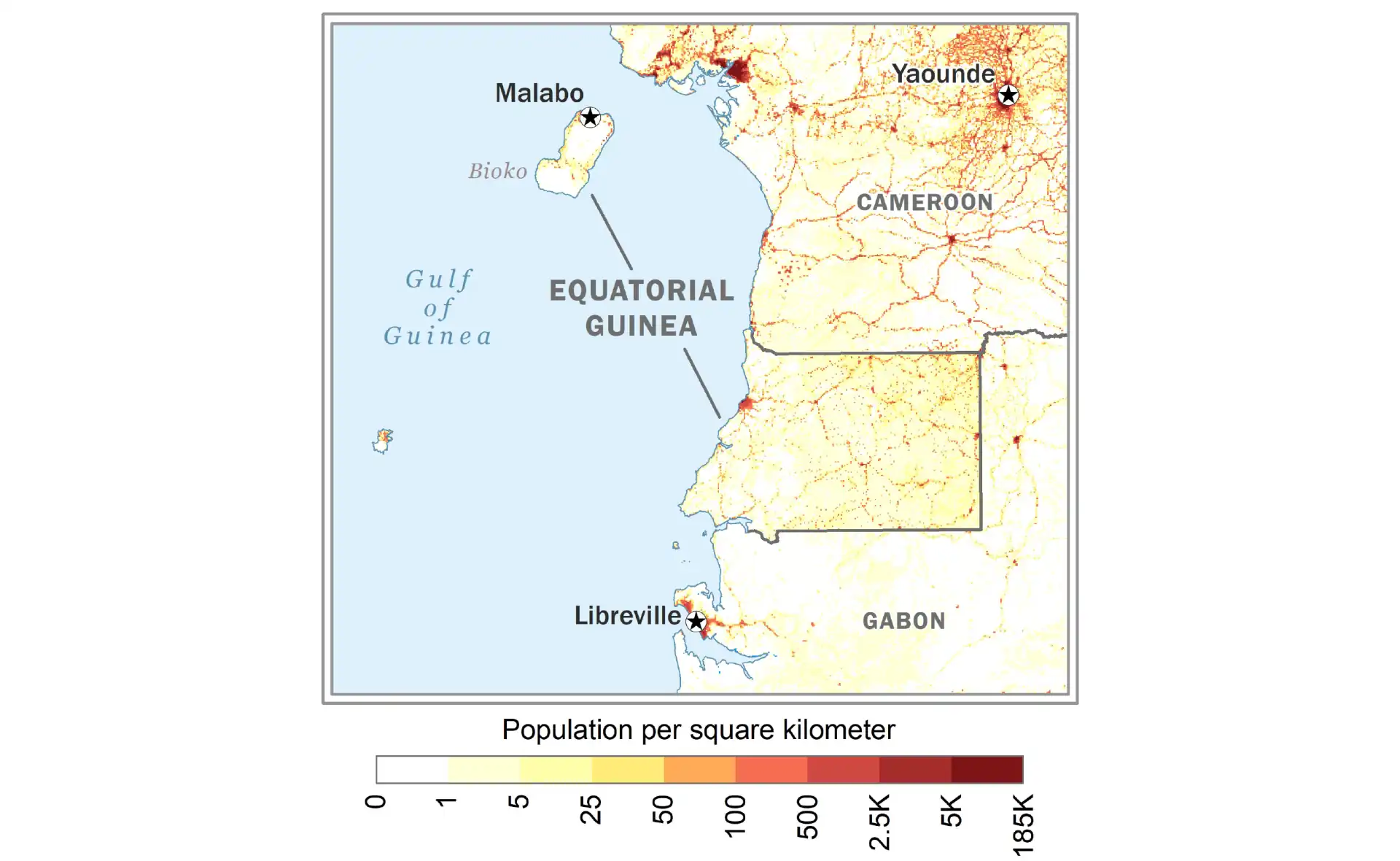
Population density varies dramatically across the country's diverse geography. Malabo on Bioko Island shows the highest density (over 500 people per square kilometer) due to its role as capital and oil industry center. Bata and its environs on the mainland also show high density (200-300 people per square kilometer). In contrast, vast areas of Rio Muni's interior rainforest remain virtually uninhabited, with density below 5 people per square kilometer. Remote Annobón Island maintains a small, isolated population of about 5,000 people, while oil industry development has created new population centers on previously sparsely inhabited coastal areas.
International Relations
Equatorial Guinea's foreign policy balances between maintaining sovereignty and attracting investment. Relations with Spain remain complex, mixing colonial resentment with economic ties. Spanish companies participate in oil and construction sectors while Spain provides some development assistance. Cultural connections through language and education create ongoing linkages despite political tensions. The large Equatoguinean community in Spain influences bilateral relations.
Regional integration efforts include membership in the Economic Community of Central African States (ECCAS) and the Central African Economic and Monetary Community (CEMAC). French and Portuguese were adopted as official languages to facilitate regional engagement. However, the Spanish linguistic heritage and oil wealth create barriers to deeper integration. A long-running dispute with Gabon over Mbanié and other islets was taken to the International Court of Justice, which ruled on the case in 2025.
China has emerged as a major partner, providing infrastructure loans and construction services without political conditions. American oil companies maintain significant investments despite human rights concerns. The government has cultivated relationships with other authoritarian states sharing similar governance models. International isolation has decreased as oil wealth enables diplomatic initiatives, including hosting African Union summits and international conferences.
Future Challenges and Opportunities
Declining oil reserves pose existential challenges to Equatorial Guinea's current model. Production has fallen from peak levels, with most easily accessible reserves depleted. New discoveries have been limited, while global energy transition threatens long-term demand. Economic diversification remains largely theoretical despite government rhetoric. The narrow elite benefiting from oil wealth shows little interest in reforms that might threaten their position.
Youth unemployment and frustration grow as the population expands while opportunities shrink. Over 60% of citizens are under 25, creating demographic pressures the current system cannot accommodate. Limited political space prevents peaceful expression of grievances, raising risks of instability. The eventual succession after more than four decades of one-man rule is a major source of uncertainty.
Potential opportunities exist in tourism, given pristine beaches and unique biodiversity, but require political opening and infrastructure development. Agricultural revival could provide employment and food security if given priority. The country's strategic location and linguistic uniqueness could enable service sector development. However, realizing these possibilities requires fundamental governance changes unlikely under current leadership. Equatorial Guinea stands at a crossroads where oil wealth's decline may force changes the political system has long resisted, determining whether this unique African nation can transform its resource curse into sustainable development.
Equatorial Guinea: Frequently Asked Questions
What is the capital of Equatorial Guinea?
The capital of Equatorial Guinea is Malabo, on Bioko Island (Ciudad de la Paz on the mainland is being built as a future capital).
What is the population of Equatorial Guinea?
Equatorial Guinea has about 1.9 million people (2025 UN estimate). The largest city is Bata.
How big is Equatorial Guinea?
Equatorial Guinea covers 28,051 km² (10,831 sq mi), made up of the mainland region Río Muni plus Bioko, Annobón and smaller islands.
What language is spoken in Equatorial Guinea and what is its currency?
Official languages: Spanish, French and Portuguese; Fang and Bubi are widely spoken. Currency: Central African CFA franc (XAF).
Which countries border Equatorial Guinea?
Equatorial Guinea borders Cameroon and Gabon. Bioko Island lies about 40 km off the coast of Cameroon.
When did Equatorial Guinea become independent?
Equatorial Guinea became independent on 12 October 1968 from Spain.