Burundi: The Heart of Africa
Burundi is a small, landlocked country in East Africa's Great Lakes region, covering 27,834 km² between Rwanda, Tanzania and DR Congo. Its political capital has been Gitega since 2019, while Bujumbura, on Lake Tanganyika, remains the largest city and economic centre. Burundi has about 14 million people (2025 UN estimate); Kirundi, French and English are official, and the country became independent from Belgium on 1 July 1962.
Burundi, officially the Republic of Burundi, is sometimes called the "Heart of Africa" because of its position and its shape on the map. It covers 27,834 square kilometres in the Great Lakes region, making it one of the smallest countries on the African mainland, yet it is home to about 14 million people, which makes it one of the most densely populated. Almost everyone speaks Kirundi, and the country is known for Lake Tanganyika, its terraced green hills, high-grown Arabica coffee and its royal drumming tradition. This page covers Burundi's location on the map, its landscapes, history, economy and culture.

Flag of Burundi - Heart of Africa
Burundi on the Map of Africa
View Burundi's central position in the Great Lakes region of East Africa, serving as a crossroads between Central and Eastern Africa:
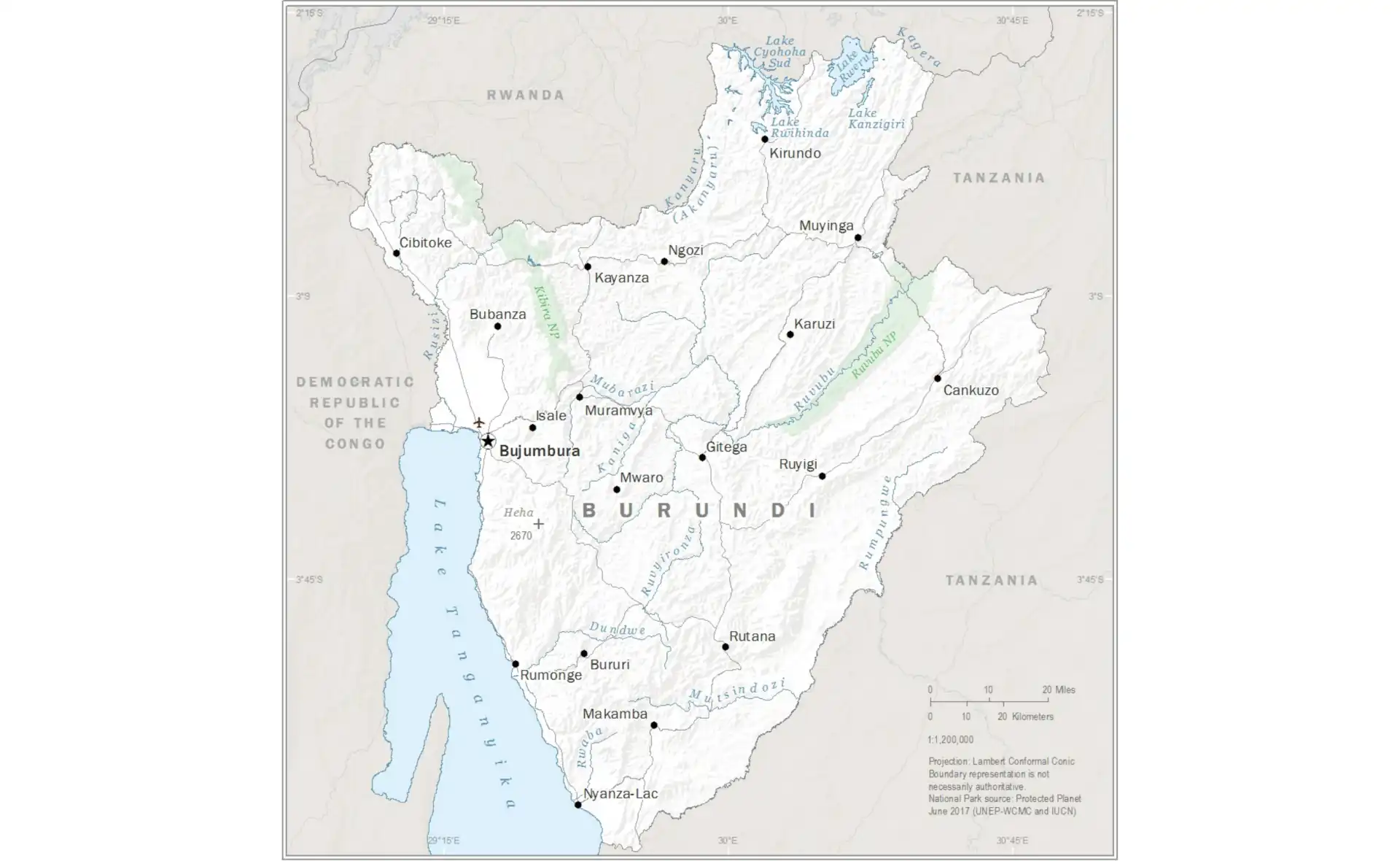
Map of Burundi
Explore the detailed map of Burundi showing Lake Tanganyika, the central highlands, coffee regions, and the rolling hills that characterize this beautiful landlocked country:
Burundi Facts at a Glance
| Official name | Republic of Burundi |
|---|---|
| Capital | Gitega (political capital since 2019); Bujumbura (economic capital) |
| Largest city | Bujumbura |
| Region | East Africa |
| Population | About 14 million (2025 UN estimate) |
| Area | 27,834 km² (10,747 sq mi) – one of Africa's smallest and most densely populated countries |
| Coastline | Landlocked |
| Official languages | Kirundi, French and English (Kirundi is spoken by almost everyone) |
| Currency | Burundian franc (BIF) |
| Government | Presidential republic |
| Independence | 1 July 1962, from Belgium (which ran Ruanda-Urundi as a UN trust territory) |
| Neighbouring countries | 3: Rwanda, Tanzania, DR Congo. The border with DR Congo runs partly through Lake Tanganyika and along the Rusizi River. |
| Administrative divisions | 5 provinces (reduced from 18 by a 2023 law that took effect in 2025), divided into communes |
| Main cities | Bujumbura, Gitega, Ngozi, Muyinga, Rumonge |
| Highest point | Mount Heha, 2,684 m (8,806 ft) |
| Rivers and lakes | Lake Tanganyika; Ruvubu, Rusizi and Malagarasi rivers. The Ruvyironza is often cited as the southernmost headstream of the Nile |
| Climate | Tropical highland: mild temperatures on the plateau (about 20°C), hotter by Lake Tanganyika; two rainy seasons |
| Economy | Mostly subsistence farming; coffee and tea are the main exports, plus some gold |
| Time zone | UTC+2 (Central Africa Time) |
| Calling code | +257 |
Population figures are rounded 2025 estimates from the UN World Population Prospects 2024 unless stated otherwise. Facts checked September 2026.
See also: Gitega city guide, countries of East Africa, landlocked countries in Africa, French-speaking countries in Africa, African independence timeline.
Burundi's Strategic Position in the Great Lakes Region
Burundi occupies a crucial position in the Great Lakes region of East Africa, nestled between Rwanda to the north, Tanzania to the east and south, and the Democratic Republic of Congo to the west. This strategic location places Burundi at the geographic heart of Africa, serving as a natural bridge between different regions and cultures. The country's position along the shores of Lake Tanganyika, one of Africa's Great Lakes, provides access to this vast freshwater resource while connecting Burundi to a network of inland waterways that have facilitated trade and cultural exchange for centuries.
Despite being landlocked and densely populated, Burundi's central location offers significant advantages for regional connectivity and trade. The country serves as a potential transit route for goods moving between the Indian Ocean and Central Africa, while its cultural and linguistic ties with neighboring countries facilitate regional cooperation. Burundi's membership in various regional organizations, including the East African Community, demonstrates its commitment to regional integration while positioning the country to benefit from expanded markets and cooperative initiatives.
Lake Tanganyika: Africa's Ancient Lake
Lake Tanganyika, the world's longest freshwater lake (about 670 km) and the second deepest (about 1,470 m), forms much of Burundi's western border. The lake is estimated to be around 9–12 million years old and holds roughly a sixth of the world's liquid surface fresh water. It is shared by four countries (Burundi, DR Congo, Tanzania and Zambia) and is famous for its hundreds of endemic cichlid fish species. For Burundi it provides fish, a transport route to Tanzanian and Congolese ports, and the country's most scenic landscapes.
The lake's crystal-clear waters and dramatic shoreline create spectacular settings for beaches, fishing villages, and recreational activities. Traditional fishing communities along the lake have developed sophisticated techniques for catching endemic cichlid species that provide protein and income for thousands of families. The lake's pristine beaches, particularly around Bujumbura and other coastal towns, offer opportunities for swimming, boating, and relaxation while providing stunning views across the water to the mountains of the Democratic Republic of Congo.
Lake Tanganyika's ecological importance extends far beyond Burundi's borders, as this ancient ecosystem serves as a living laboratory for evolution and biodiversity research. The lake's unique chemistry, great depth, and isolation have allowed species to evolve independently, creating remarkable diversity that attracts researchers and conservationists from around the world. Burundi's commitment to protecting this natural heritage demonstrates the country's understanding of the lake's global significance while recognizing its crucial importance for local livelihoods.
Rolling Hills and Highlands
Burundi's landscape is a succession of steep, densely farmed hills. In the west, the land drops to the Imbo plain along Lake Tanganyika and the Rusizi River (about 775 m above sea level). Above it rises the Congo–Nile Ridge, a mountain chain that reaches 2,684 metres at Mount Heha, the highest point in the country. East of the ridge lie the central plateaus (roughly 1,500–2,000 m), which descend to lower, drier land along the Tanzanian border in the east and the Kumoso depression in the south-east.
The Congo–Nile Ridge is a continental divide: streams on its western side flow to Lake Tanganyika and eventually the Congo River, while those on the eastern side, such as the Ruvubu and Ruvyironza, feed the Kagera River and Lake Victoria, and so belong to the Nile basin. A spring near Rutovu in southern Burundi is often cited as the southernmost source of the Nile, marked by a small pyramid monument.
Burundi lies on the western (Albertine) branch of the East African Rift, which formed the deep trough of Lake Tanganyika and still causes occasional earthquakes. Hot springs, such as those at Mugara near Rumonge, are a sign of this activity. The combination of altitude, reliable rainfall and fertile hillside soils makes the highlands well suited to coffee, tea and food crops.
Coffee Culture: Burundi's Liquid Gold
Coffee is Burundi's leading export crop and, together with tea, one of its main sources of foreign currency. Almost all of it is high-grown Arabica (mostly the Bourbon variety), produced by hundreds of thousands of smallholder families who each tend a few hundred trees on the hillsides. Cherries are taken to washing stations for wet processing, which gives Burundian coffee its clean, bright character.
The sector was nationalised and re-liberalised several times; cooperatives and private washing stations now handle much of the processing, and specialty buyers seek out Burundian lots through competitions such as the Cup of Excellence. Output varies considerably from year to year because of weather, ageing trees and the natural on/off-year cycle of coffee plants.
Traditional Drumming: The Heartbeat of Burundi
Burundi's drumming tradition is one of Africa's best-known cultural performances. Under the kingdom, sacred drums were symbols of royal power and were played at royal ceremonies and the umuganuro harvest festival. The drums (ingoma) are carved from a single tree trunk and covered with cowhide; performers carry them on their heads, then play them in a semicircle around a central drum while taking turns to dance and leap in front of the group.
Troupes such as the drummers of Gishora, near Gitega, and the internationally touring Royal Drummers of Burundi have brought the performance to audiences worldwide. Since 2017 a government decree has restricted performances to official and cultural occasions and set rules on who may play, to protect the tradition's ceremonial character.
UNESCO Recognition and Cultural Preservation
In 2014 UNESCO inscribed the "Ritual dance of the royal drum" on its Representative List of the Intangible Cultural Heritage of Humanity, recognising the drumming as a living tradition that combines rhythm, dance, heroic poetry and traditional songs.
Gitega and Bujumbura: Political and Economic Capitals
Burundi has two main cities with distinct roles. Gitega, in the central highlands, became the political capital in 2019; it was the seat of the old monarchy and is home to the National Museum. Bujumbura, on the north-eastern shore of Lake Tanganyika, was the capital from independence until then and remains the largest city (roughly 1 million people), the economic capital and the location of the main port, the international airport and most businesses and embassies. The move of government institutions to Gitega has been gradual.
Bujumbura's lakeside beaches, fishing harbour and markets make it the main base for visitors. Local dishes include ubugari (a stiff cassava or maize dough), beans, plantains and fresh fish from the lake such as mukeke and ndagala (small sardine-like fish). Other towns include Ngozi in the north, Muyinga in the north-east and Rumonge on the lake shore south of Bujumbura.
Cultural Heritage and Social Cohesion
Burundians share a common language (Kirundi), culture and, for most, Christian faith, but society has long been divided between the Hutu majority (about 85%), the Tutsi minority (about 14%) and the small Twa community (about 1%). These categories were hardened under colonial rule and became the fault line of political violence after independence. Today the constitution sets ethnic quotas for government, parliament and the army as part of the post-war power-sharing settlement.
Traditional architecture, crafts, and agricultural practices demonstrate sophisticated adaptation to local environments while reflecting aesthetic values and practical knowledge developed over centuries. Traditional houses, built with local materials and designed for climate conditions, showcase architectural techniques that maximize comfort while minimizing environmental impact. Handicrafts including basketry, pottery, metalwork, and textiles preserve traditional skills while providing income opportunities for artisans who maintain cultural knowledge and practices.
Oral traditions including folktales, proverbs, historical narratives, and praise poetry preserve cultural memory while transmitting values and knowledge to younger generations. These traditions, often accompanied by music and dance, create educational and entertainment opportunities that strengthen community bonds while maintaining cultural continuity. Traditional healing practices, agricultural knowledge, and environmental management techniques represent sophisticated understanding of local ecosystems and human-environment relationships.
Agriculture and Rural Life
Agriculture is the foundation of Burundi's economy, employing the large majority of the workforce, mostly on small family plots. With so many people living on so little land, farms are small and hillsides are intensively cultivated, often terraced to limit soil erosion.
Food crops including beans, maize, sweet potatoes, bananas, and cassava provide food security while supporting diverse diets that reflect local preferences and nutritional needs. Traditional varieties of these crops, adapted to local conditions over generations, demonstrate agricultural resilience while preserving genetic diversity that could be crucial for future food security. Women play central roles in agricultural production, food processing, and household nutrition while participating in cooperative organizations that provide support and resources.
Livestock keeping, particularly cattle, goats, and poultry, provides protein, income, and social status while supporting agricultural systems through manure and draft power. Traditional pastoralism practices demonstrate sophisticated understanding of animal husbandry while respecting cultural values that assign social significance to livestock ownership. Beekeeping, fish farming, and other complementary activities diversify rural incomes while supporting ecosystem services and biodiversity conservation.
Biodiversity and Conservation
Burundi's small size belies its significant biodiversity, with varied ecosystems that support endemic species, migratory wildlife, and important habitats for both terrestrial and aquatic life. The country's position at the intersection of different biogeographical zones creates opportunities for species diversity while its elevation gradients support different ecosystems from lakeshores to montane forests. Protected areas, though limited in size, preserve important habitats while providing opportunities for ecotourism and research.
Kibira National Park, protecting montane forest ecosystems in northern Burundi, harbors primates including chimpanzees and various monkey species while supporting endemic birds and plants. The forest provides crucial watershed functions while offering hiking opportunities and wildlife viewing experiences. However, pressure from agricultural expansion and fuelwood collection creates conservation challenges that require balancing protection needs with human welfare considerations.
Lake Tanganyika's aquatic ecosystems support remarkable fish diversity, with hundreds of endemic cichlid species that demonstrate rapid evolution and speciation processes. These fish communities provide important protein sources while supporting tourism through diving and snorkeling opportunities. However, overfishing, pollution, and habitat degradation threaten these unique ecosystems, requiring regional cooperation and sustainable management practices to ensure long-term conservation.
History: From Kingdom to Republic
The Kingdom of Burundi emerged by the 17th century under a mwami (king) and was one of the few African states whose borders largely survived colonisation. Germany claimed it as part of German East Africa in the 1890s; after the First World War, Belgium administered it together with Rwanda as Ruanda-Urundi, first under a League of Nations mandate and then as a UN trust territory. Burundi became independent on 1 July 1962 as a constitutional monarchy, and the monarchy was abolished in 1966.
The following decades were marked by military rule and repeated waves of ethnic violence, notably in 1972 and 1993. The assassination of Burundi's first elected Hutu president in 1993 triggered a civil war that lasted until the mid-2000s and killed an estimated 300,000 people. The Arusha Peace Agreement (2000) and later ceasefires established the power-sharing constitution in force today (revised in 2018). A political crisis in 2015 led hundreds of thousands of people to flee, many of whom have since returned. In 2019 the political capital moved to Gitega, and in 2025 the country's 18 provinces were merged into 5 larger ones.
Challenges and Resilience
Burundi is one of the world's poorest countries by GDP per person. Its main challenges are high population density and rapid population growth, dependence on rain-fed farming, shortages of foreign currency and fuel, and vulnerability to floods and droughts, including the rising level of Lake Tanganyika, which has flooded parts of Bujumbura and Rumonge.
Population pressure on limited land resources creates intense competition for agricultural land while driving environmental degradation including deforestation, soil erosion, and wetland conversion. These environmental challenges threaten both biodiversity and agricultural productivity while increasing vulnerability to climate change impacts. However, traditional knowledge about sustainable agriculture and community-based natural resource management provides foundations for addressing these challenges through integrated approaches.
Since the civil war ended, peace-building has focused on reconciliation, the reintegration of former combatants and refugees, and a Truth and Reconciliation Commission investigating past violence. International donors remain important funders of health, education and development programmes.
Education and Human Development
Burundi has made significant investments in education despite limited resources, with initiatives to increase primary school enrollment, improve quality, and expand access to secondary and higher education. The University of Burundi and other institutions contribute to human resource development while building research capacity in fields relevant to national development needs. However, challenges remain in providing quality education in rural areas while ensuring graduates have skills relevant to economic opportunities.
Health improvements include progress in reducing child mortality, improving maternal health, and controlling infectious diseases through community-based programs and international support. However, malnutrition remains a significant challenge that affects both health and educational outcomes while limiting human development potential. Integrated approaches that address nutrition, health, and education together demonstrate potential for achieving better outcomes while building resilience.
Regional Integration and Development
Burundi joined the East African Community (EAC) in 2007, alongside its membership of the Common Market for Eastern and Southern Africa (COMESA) and the Economic Community of Central African States (ECCAS). Most of its imports arrive by road or by lake from the Tanzanian port of Dar es Salaam, and a standard-gauge railway linking Burundi to Tanzania's network is planned.
Cultural Tourism and Heritage Preservation
Burundi's rich cultural heritage offers significant potential for cultural tourism that showcases traditional drumming, crafts, architecture, and community life while providing economic benefits for local communities. Cultural tourism initiatives could include visits to drumming centers, craft workshops, traditional farms, and cultural festivals that provide authentic experiences while supporting cultural preservation. These initiatives require careful planning to ensure tourism benefits communities while respecting cultural values and practices.
Heritage preservation efforts focus on documenting, protecting, and transmitting traditional knowledge while adapting practices to contemporary contexts. These efforts include training programs for traditional practitioners, documentation of cultural practices, and integration of cultural education into formal schooling. International recognition of Burundian cultural heritage creates opportunities for cultural exchange while building appreciation for traditional knowledge and practices.
Burundi at a Glance
On the map, Burundi sits just south of the equator between Rwanda, Tanzania and DR Congo, with Lake Tanganyika on its western side. Its political capital is Gitega and its largest city is Bujumbura. It is small, green, hilly and crowded, and its economy rests on smallholder farming, coffee and tea.
Burundi: Frequently Asked Questions
What is the capital of Burundi?
The capital of Burundi is Gitega (political capital since 2019); Bujumbura is the economic capital and largest city.
What is the population of Burundi?
Burundi has about 14 million people (2025 UN estimate). The largest city is Bujumbura.
How big is Burundi?
Burundi covers 27,834 km² (10,747 sq mi), one of Africa's smallest and most densely populated countries.
What language is spoken in Burundi and what is its currency?
Official languages: Kirundi, French and English (Kirundi is spoken by almost everyone). Currency: Burundian franc (BIF).
Which countries border Burundi?
Burundi borders Rwanda, Tanzania and DR Congo. The border with DR Congo runs partly through Lake Tanganyika and along the Rusizi River.
When did Burundi become independent?
Burundi became independent on 1 July 1962 from Belgium (which ran Ruanda-Urundi as a UN trust territory).