Physical Map of Africa: Rivers, Mountains, Deserts and Lakes
A physical map of Africa shows the continent's landforms rather than its borders: the Sahara across the north, the Sahel and savanna belts, the Congo Basin rainforest on the equator, the East African highlands and Great Rift Valley, and the Kalahari and Namib deserts in the south. The highest point is Mount Kilimanjaro (5,895 m) in Tanzania and the lowest is Lake Assal in Djibouti (about 155 m below sea level). Africa covers about 30.3 million km², and most of it is a series of high plateaus: "High Africa" in the east and south, and lower basins and plains in the north and west. Where a political map shows countries and capitals, a physical map explains the terrain those borders sit on.
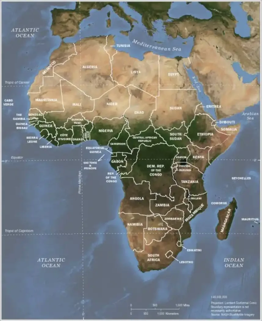
Last updated: September 2026
Key Physical Facts About Africa
| Feature | Name | Location / figure |
|---|---|---|
| Highest point | Mount Kilimanjaro (Kibo, Uhuru Peak) | 5,895 m, north-east Tanzania |
| Lowest point | Lake Assal | About 155 m below sea level, Djibouti |
| Longest river | Nile | About 6,650 km, Lake Victoria basin to the Mediterranean |
| Largest river basin | Congo | About 4 million km², Central Africa |
| Largest lake | Lake Victoria | About 68,800 km², Uganda, Kenya and Tanzania |
| Deepest lake | Lake Tanganyika | About 1,470 m, Tanzania, DR Congo, Burundi and Zambia |
| Largest desert | Sahara | About 9 million km², North Africa |
| Largest island | Madagascar | About 587,000 km², Indian Ocean |
| Largest waterfall (by width & flow combined) | Victoria Falls | About 1,700 m wide, Zambia–Zimbabwe border |
Deserts
Deserts dominate large parts of Africa's physical map, both north and south of the equator.
- The Sahara – the world's largest hot desert, covering roughly 9 million km² across North Africa from the Atlantic to the Red Sea. Its highest point is Emi Koussi (about 3,415 m) in Chad's Tibesti Mountains.
- The Kalahari – a vast semi-arid basin spanning Botswana, Namibia and South Africa.
- The Namib – one of the oldest deserts on Earth, running along the Atlantic coast of Namibia.
Rivers
Africa's rivers have shaped its civilisations, agriculture and borders for millennia.
- The Nile – the longest river in Africa (≈6,650 km), flowing north to the Mediterranean.
- The Congo – Africa's second-longest river (about 4,700 km) and the deepest river in the world, with the continent's largest discharge; it drains the Central African rainforest into the Atlantic.
- The Niger – West Africa's principal river (about 4,200 km), rising in Guinea and curving through Mali, Niger and Nigeria to a large delta on the Gulf of Guinea.
- The Zambezi – about 2,700 km long, home to Victoria Falls and the Kariba and Cahora Bassa dams, draining Southern Africa into the Indian Ocean.
- The Orange – South Africa's longest river, forming part of the border with Namibia before reaching the Atlantic.
Lakes and the Great Rift Valley
East Africa is defined by the Great Rift Valley, a continental fracture stretching thousands of kilometres and cradling some of the world's largest lakes.
- Lake Victoria – Africa's largest lake and the world's largest tropical lake, shared by Uganda, Kenya and Tanzania. It sits in a basin between the two branches of the rift rather than in the rift itself.
- Lake Tanganyika – the world's second-deepest and second-oldest freshwater lake.
- Lake Malawi (Lake Nyasa) – bordered by Malawi, Mozambique and Tanzania, with more fish species than any other lake.
- Lake Turkana – the world's largest permanent desert lake, in northern Kenya.
Mountains and Highlands
From volcanic peaks to ancient ranges, Africa's high ground is concentrated in the east and north-west.
- Mount Kilimanjaro – Africa's highest point at 5,895 m, in Tanzania.
- Mount Kenya – the continent's second-highest peak (5,199 m), in central Kenya.
- The Rwenzori Mountains – the "Mountains of the Moon" on the Uganda–DR Congo border, rising to 5,109 m (Margherita Peak).
- The Drakensberg – the highest range in Southern Africa, reaching 3,482 m at Thabana Ntlenyana in Lesotho.
- The Atlas Mountains – a 2,500 km chain across Morocco, Algeria and Tunisia.
- The Ethiopian Highlands – often called the "Roof of Africa", a plateau mostly above 1,500 m and the source of the Blue Nile (Lake Tana). The highest peak is Ras Dashen (4,550 m).
Forests, Savannas and the Sahel
Between desert and rainforest lies a series of broad climate belts that mirror the continent's physical map. The Congo Basin rainforest, the second-largest on Earth, straddles the equator. To its north and south stretch tropical savannas teeming with wildlife. The Sahel, a semi-arid transition zone, separates the Sahara from the savanna and is the focus of the Great Green Wall reforestation initiative.
High Africa and Low Africa
Geographers often split the continent into two relief zones along a line running roughly from Angola to Ethiopia. Low Africa, in the north and west, is mostly plains and low plateaus between 150 and 600 m, broken by isolated uplands such as the Ahaggar and Tibesti in the Sahara and the Fouta Djallon in Guinea. High Africa, in the east and south, is dominated by plateaus above 1,000 m, the Ethiopian and East African highlands, the volcanic peaks of the rift zone, and the Great Escarpment that rims Southern Africa. Because so much of the interior is high plateau, many African rivers drop over falls and rapids near the coast, which limited river navigation from the sea.
Coastline and Islands
Africa's coastline is short for its size (about 26,000 km) and fairly smooth, with few deep natural harbours. Its main indentations are the Gulf of Guinea in the west, the Gulf of Sidra on the Libyan coast, and the Gulf of Aden and Red Sea in the north-east. Offshore lie Madagascar, the world's fourth-largest island, and the island nations of Cape Verde, São Tomé and Príncipe, Comoros, Mauritius and Seychelles. See the full list of island countries in Africa.
Physical Map vs Political Map
Physical and political maps describe the same continent in two different languages. A physical map explains why the political map looks the way it does: rivers and mountain ranges often became borders, deserts isolated kingdoms, and fertile valleys concentrated population. To see the human side of the map, explore our political map of Africa or browse the full list of African countries.
Using This Interactive Physical Map
The interactive map above lets you zoom across deserts, river systems and mountain ranges using open mapping data. It is a helpful study aid for geography students, teachers building lesson plans, and anyone curious about the natural wonders of Africa. Ready to test what you have learned? Try the Africa map quiz or the Africa map game.
Frequently Asked Questions
What is a physical map of Africa?
A physical map of Africa shows the continent's natural features: deserts such as the Sahara and Kalahari, rivers such as the Nile and Congo, lakes such as Lake Victoria, mountain ranges such as the Atlas, and highlands like the Ethiopian Plateau. It focuses on landforms and elevation rather than country borders.
What are the main landforms on Africa's physical map?
The key landforms are the Sahara Desert in the north, the Sahel belt, the Congo Basin rainforest, the East African highlands and the Great Rift Valley, the Kalahari and Namib deserts in the south, and major mountains including Kilimanjaro, Mount Kenya and the Atlas range.
What is the longest river on the physical map of Africa?
The Nile is the longest river in Africa and one of the longest in the world at about 6,650 kilometres, flowing north from East Africa to the Mediterranean. The Congo, Niger and Zambezi are the other major rivers.
What is the highest mountain in Africa?
Mount Kilimanjaro in Tanzania is the highest point in Africa at 5,895 metres. It is a dormant volcano rising from the surrounding plains.
What is the lowest point in Africa?
Lake Assal in Djibouti is the lowest point in Africa, at about 155 metres below sea level. It is a highly saline crater lake in the Afar depression.
How is a physical map different from a political map of Africa?
A physical map shows natural geography such as rivers, mountains and deserts, while a political map shows country borders, capitals and cities. The two are complementary ways of mapping the same continent.