Where Is Mount Kilimanjaro Located on a Map of Africa?
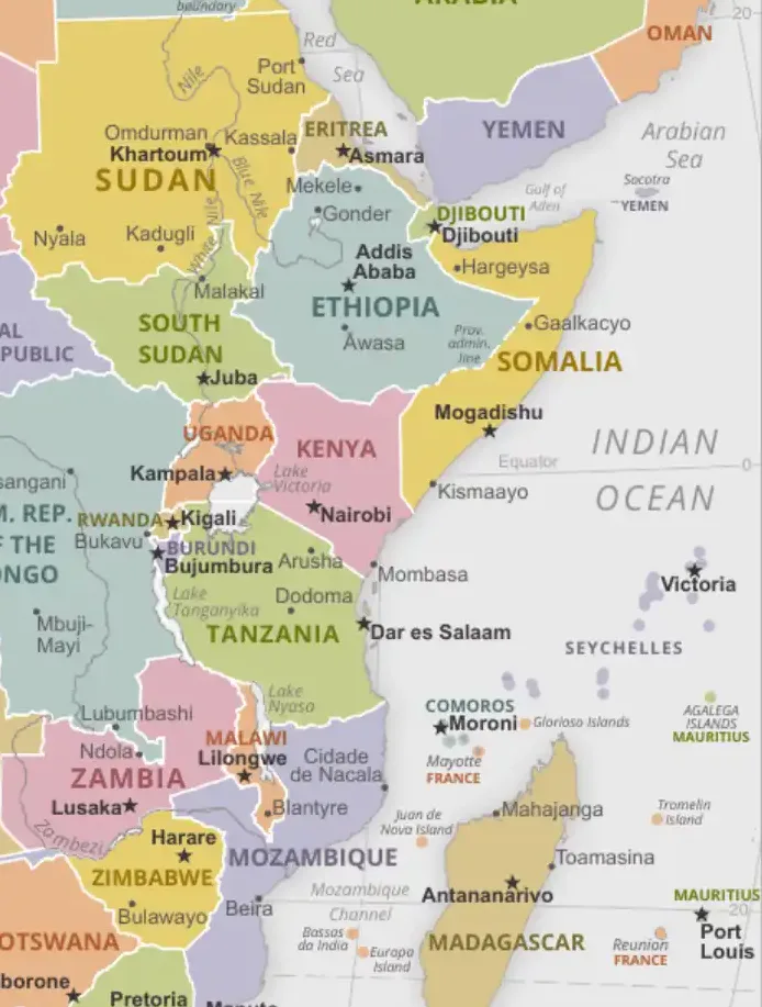
Mount Kilimanjaro is in northeastern Tanzania, just south of the border with Kenya. Its summit, Uhuru Peak (5,895 m / 19,341 ft), lies at about 3°04′S, 37°21′E — about 340 km south of the equator, about 35 km north of the town of Moshi and some 200 km south-east of Nairobi. On a map of Africa, look at East Africa just inland from the Indian Ocean coast, where the Tanzania–Kenya border runs north-west from the sea: Kilimanjaro rises alone from the plains on the Tanzanian side, facing Kenya's Amboseli National Park. It is Africa's highest mountain and the world's tallest free-standing mountain.
Last updated: September 2026
Interactive Mount Kilimanjaro Map
Understanding Mount Kilimanjaro: Location and Geography
Mount Kilimanjaro's location in East Africa places it at the heart of one of the continent's most geologically active and biodiverse regions. The mountain rises dramatically from the surrounding savanna plains, creating a unique ecosystem that ranges from tropical rainforest at its base to arctic conditions at its summit.
Precise Geographic Location
Coordinates: Mount Kilimanjaro is located at approximately 3°04′33″S 37°21′12″E, placing it firmly within Tanzania's Kilimanjaro Region, near the town of Moshi. The mountain sits about 200 kilometers south-east of Nairobi, Kenya, and roughly 450 kilometers north-west of Dar es Salaam, Tanzania's largest city.
Proximity to Kenya Border: While Kilimanjaro is entirely within Tanzania, its northern slopes reach almost to the Kenya-Tanzania border, and the mountain dominates the view from Amboseli National Park in Kenya. This proximity means the mountain is easily accessible from both countries, with many visitors flying into Nairobi before traveling overland to Tanzania for their climb.
Regional Context: Kilimanjaro stands east of the Eastern (Gregory) branch of the Great Rift Valley. Its volcanism is linked to the same tectonic forces that created the rift, resulting in the dramatic landscapes that characterize this region of Africa.
The Three Volcanic Cones
Mount Kilimanjaro actually consists of three distinct volcanic cones, each with its own characteristics and geological history:
Kibo (5,895m)
Status: Dormant volcano with Uhuru Peak at summit
Features: Snow-capped peak, glaciers, crater rim
Significance: Highest point in Africa, main climbing objective
Mawenzi (5,149m)
Status: Extinct volcano with rugged peaks
Features: Jagged rocky spires, technical climbing
Significance: Second highest peak, advanced climbing only
Shira (3,962m)
Status: Extinct volcano, oldest cone
Features: Collapsed caldera, plateau formation
Significance: Part of several climbing routes, scenic views
Kilimanjaro National Park
Protected Area: The mountain and its surrounding ecosystems are protected within Kilimanjaro National Park, established in 1973 and covering 1,688 square kilometers. The park was designated a UNESCO World Heritage Site in 1987, recognizing its outstanding natural value and unique ecosystems.
Buffer Zones: The national park is surrounded by forest reserves and wildlife management areas that provide additional protection for the mountain's watersheds and wildlife corridors. These buffer zones are crucial for maintaining the ecological integrity of the broader Kilimanjaro ecosystem.
International Recognition: Beyond its UNESCO status, Kilimanjaro has been recognized by various international conservation organizations as a critical ecosystem for biodiversity conservation and climate research.
Climbing Routes and Access Points
Mount Kilimanjaro offers seven official climbing routes, each with different characteristics in terms of difficulty, scenery, duration, and success rates. Understanding these routes is essential for anyone planning to climb Africa's highest peak.
Main Climbing Routes
Machame Route (Whiskey Route): Considered one of the most scenic routes, the Machame Route takes 6-7 days and offers excellent acclimatization opportunities. Starting from Machame Gate, this route crosses multiple climate zones and provides spectacular views of the Barranco Wall and Lava Tower.
Marangu Route (Coca-Cola Route): The only route offering hut accommodation instead of camping, Marangu is often considered the "easiest" route, though it has lower success rates due to rapid ascent profile. The 5-6 day route starts from Marangu Gate and follows a more direct path to the summit.
Lemosho Route: A newer route offering excellent acclimatization and some of the best scenery on the mountain. The 7-8 day trek starts from Londorossi Gate and crosses the Shira Plateau before joining the Machame Route for the final ascent.
Rongai Route: The only route approaching from the north (Kenya side), Rongai offers a more gradual ascent and is less crowded than southern routes. This 6-7 day route provides unique perspectives of the mountain and good wildlife viewing opportunities.
Northern Circuit: The longest route (8-9 days) offering the best acclimatization and highest success rates. This newer route circles around the northern side of the mountain, providing unparalleled views and excellent preparation for summit attempts.
Shira Route: Starting at high altitude (3,500m), this route is only recommended for well-acclimatized climbers. It offers beautiful views of the Shira Plateau but higher risk of altitude sickness due to rapid initial altitude gain.
Umbwe Route: The most direct and challenging route, recommended only for experienced climbers. This steep, short route offers dramatic scenery but poor acclimatization opportunities and lower success rates.
Gateway Towns and Access
Moshi: The main base town for Kilimanjaro climbs, Moshi offers numerous climbing operators, equipment rental, and accommodation options. Located at about 900m elevation and some 35km from the summit, Moshi provides good pre-climb acclimatization and easy access to most route starting points.
Arusha: A larger city about 80km west of Kilimanjaro, Arusha is Tanzania's safari hub and an alternative base for climbs. Its own airport handles mainly domestic and regional flights.
Transportation: Most climbers reach Kilimanjaro through Kilimanjaro International Airport (JRO), located between Moshi and Arusha. Alternatively, many visitors fly into Nairobi and travel overland, which offers opportunities to see more of East Africa but requires border crossing procedures.
Ecosystems and Climate Zones
Mount Kilimanjaro's height and equatorial location create a unique succession of climate zones and ecosystems, essentially allowing climbers to experience a journey from tropical Africa to arctic conditions within just a few days of hiking.
The Five Ecological Zones
Cultivation Zone (800-1,800m): The lower slopes of Kilimanjaro support intensive agriculture, with small farms growing coffee, bananas, maize, and other crops. This zone is home to the Chagga people, who have developed sophisticated irrigation systems and agricultural techniques adapted to the mountain environment.
Rainforest Zone (1,800-2,800m): Dense tropical rainforest encircles the mountain, supported by moisture from clouds that form as air masses rise against the mountain slopes. This zone hosts diverse wildlife including monkeys, birds, and numerous plant species, many of which are endemic to the region.
Heather and Moorland Zone (2,800-4,000m): Above the forest line, the landscape transitions to alpine moorland characterized by giant heathers, lobelias, and groundsels. This zone experiences significant temperature variations and occasional frost, representing a unique high-altitude ecosystem.
Alpine Desert Zone (4,000-5,000m): Extreme conditions with little precipitation, intense solar radiation, and dramatic temperature swings characterize this zone. Only specially adapted plants can survive here, and the landscape becomes increasingly barren as elevation increases.
Arctic Zone (5,000m+): The summit area experiences arctic conditions with glaciers, permanent snow, and temperatures regularly below freezing. Very few life forms can survive in this harsh environment, making it truly otherworldly for visitors from lower elevations.
Climate and Weather Patterns
Seasonal Variations: Kilimanjaro has two main dry seasons (roughly late December to early March, and June to October) and two wet seasons (the long rains from about late March to May, and the shorter rains in November). The dry seasons offer the best climbing conditions, though the mountain can be climbed year-round.
Temperature Ranges: Temperatures vary dramatically with altitude, from tropical warmth at the base (20-30°C) to arctic cold at the summit (-15 to -25°C). Climbers must be prepared for this extreme range within a single climb.
Precipitation Patterns: The southern slopes receive more rainfall than the northern slopes due to prevailing wind patterns. This creates different vegetation patterns and climbing conditions on various routes.
Glaciers and Climate Change
Retreating Ice: Kilimanjaro's glaciers have been retreating for more than a century. The ice cover has shrunk by over 80% since the early 1900s, and scientists expect most or all of it to disappear within the coming decades.
Scientific Research: The mountain serves as an important site for climate research, with scientists studying ice cores, vegetation changes, and ecosystem responses to changing conditions. This research provides valuable insights into global climate patterns and environmental change.
Conservation Implications: Glacier retreat affects local water supplies, ecosystem dynamics, and the mountain's iconic appearance. Conservation efforts focus on understanding and mitigating these changes while protecting the broader mountain ecosystem.
Wildlife and Biodiversity
Despite its high altitude and challenging conditions, Mount Kilimanjaro supports remarkable biodiversity across its various elevation zones. The mountain's ecosystems host numerous endemic species and serve as important habitat for East African wildlife.
Forest Zone Wildlife
Primates: The rainforest zone hosts several primate species, including blue monkeys and black and white colobus monkeys. These primates play important roles in forest ecosystems through seed dispersal and are often encountered by climbers on lower route sections.
Large Mammals: Elephants occasionally move through the forest zone, following traditional migration routes between Kilimanjaro and nearby protected areas. Buffalo and bushbuck also inhabit the forest, though they are rarely seen due to dense vegetation and their secretive nature.
Carnivores: Leopards roam the forest zones and occasionally higher elevations, though sightings are extremely rare. Smaller carnivores include servals, civets, and various mongoose species adapted to forest environments.
Bird Life
Forest Species: The mountain supports well over 100 bird species, including numerous endemic and near-endemic species. Notable birds include the Kilimanjaro white-eye, Abbott's starling, and various sunbird species that feed on flowering plants throughout the forest.
High Altitude Specialists: Several bird species have adapted to high-altitude conditions on Kilimanjaro, including the lammergeier (bearded vulture), which soars around the peaks, and various eagles and buzzards that hunt in the moorland zones.
Endemic and Rare Species
Plant Endemism: Kilimanjaro hosts numerous plant species found nowhere else on Earth, including several species of giant groundsels (Dendrosenecio) and lobelias that have evolved to survive extreme high-altitude conditions.
Invertebrate Diversity: The mountain supports remarkable invertebrate diversity, including numerous endemic insect species. High-altitude zones host specially adapted spiders, beetles, and other arthropods that survive extreme conditions.
Conservation Status: Many of Kilimanjaro's endemic species face threats from climate change, habitat loss, and human pressure. Conservation efforts focus on protecting critical habitats and understanding species responses to environmental changes.
Cultural Heritage and Local Communities
Mount Kilimanjaro holds deep cultural significance for local communities and has played important roles in East African history, trade, and traditional beliefs. Understanding this cultural context enriches any visit to the mountain.
The Chagga People
Traditional Inhabitants: The Chagga people have lived on Kilimanjaro's slopes for centuries, developing sophisticated agricultural systems adapted to the mountain environment. They created elaborate irrigation networks called "mfongo" that channel mountain water to terraced farms throughout the foothills.
Agricultural Innovations: Chagga farming systems represent one of Africa's most intensive and sustainable agricultural practices, combining coffee cultivation with food crops like bananas, maize, and beans. These multi-story cropping systems maximize land use while maintaining soil fertility.
Cultural Practices: Traditional Chagga society was organized around mountain chiefdoms, each controlling specific areas of the mountain. Cultural practices include traditional brewing, distinctive architecture using volcanic stones, and complex social systems adapted to mountain living.
Modern Adaptations: Contemporary Chagga communities have adapted to modern challenges while maintaining many traditional practices. Many community members work in tourism, guiding climbers and providing services, while continuing traditional farming and cultural practices.
Spiritual and Cultural Significance
Sacred Mountain: Kilimanjaro holds spiritual significance for various East African peoples, who traditionally viewed the mountain as the dwelling place of gods or spirits. Many cultural practices and beliefs center around the mountain's power and significance.
The Name: The origin of the name "Kilimanjaro" is uncertain. Suggested meanings from Swahili and Kichagga include "mountain of whiteness" and "mountain of greatness". The summit was called Kaiser-Wilhelm-Spitze in the German colonial period and renamed Uhuru ("freedom") Peak after Tanganyika's independence in 1961.
Ceremonial Uses: Traditional ceremonies and rituals have historically been associated with the mountain, including practices related to weather prediction, agricultural cycles, and community welfare. Some of these traditions continue today alongside modern practices.
Historical Exploration and Documentation
Early European Contact: The German missionary Johannes Rebmann was the first European to report the snow-capped mountain, in 1848. The first recorded ascent to the summit was made in 1889 by Hans Meyer and Ludwig Purtscheller with their local guide Yohani Lauwo.
Colonial Period: During German and later British colonial rule, the mountain region was incorporated into colonial administrative systems, affecting traditional land use patterns and cultural practices. Coffee cultivation was expanded and commercialized during this period.
Independence and Development: Following Tanzanian independence, the mountain region has experienced significant development in tourism, education, and infrastructure, while efforts continue to balance modernization with cultural preservation and environmental protection.
Tourism and Economic Impact
Mount Kilimanjaro is one of Tanzania's most important tourism assets, generating significant revenue for local communities and the national economy while providing employment for thousands of people in the region.
Climbing Tourism Industry
Annual Visitors: Approximately 35,000-50,000 people attempt to climb Kilimanjaro each year, making it one of the world's most popular high-altitude trekking destinations. Success rates vary by route and preparation, ranging from 45% to 90% depending on itinerary and acclimatization strategies.
Economic Impact: Climbing tourism is a major source of park revenue and supports thousands of jobs for guides, porters, cooks and support staff. Many local communities depend directly or indirectly on mountain tourism for their livelihoods.
Support Industry: The climbing industry supports extensive service networks including equipment suppliers, transportation providers, accommodation facilities, and food suppliers. This creates multiplier effects that benefit broader regional economies.
Cultural and Wildlife Tourism
Cultural Experiences: Many visitors combine Kilimanjaro climbs with cultural tourism experiences, including visits to Chagga villages, coffee plantation tours, and traditional craft workshops. These activities provide additional income for local communities while sharing cultural heritage.
Wildlife Integration: Kilimanjaro tourism often combines with broader East African safari experiences, as visitors explore nearby parks like Serengeti, Ngorongoro Crater, and Amboseli.
Sustainable Tourism Challenges
Environmental Pressure: High visitor numbers create environmental pressures including trail erosion, waste management challenges, and impacts on fragile high-altitude ecosystems. Park management works to balance access with conservation needs.
Community Benefits: Ensuring that tourism benefits reach local communities remains an ongoing challenge. Efforts focus on promoting community-owned tourism enterprises, fair employment practices, and capacity building for local participation in the tourism industry.
Conservation Challenges and Efforts
Mount Kilimanjaro faces numerous conservation challenges related to climate change, human pressure, and ecosystem management. Understanding these challenges and ongoing conservation efforts is crucial for the mountain's long-term protection.
Climate Change Impacts
Glacier Retreat: The most visible impact of climate change on Kilimanjaro is the dramatic retreat of its glaciers and ice fields. Scientists estimate that the mountain's ice cover has decreased by over 80% since the early 20th century, with complete disappearance possible within decades.
Ecosystem Shifts: Changing temperature and precipitation patterns are causing shifts in vegetation zones, with forest lines moving upward and alpine species facing increasing pressure. These changes affect wildlife habitat and ecosystem functioning.
Water Resources: Glacier retreat and changing precipitation patterns affect water availability for local communities and ecosystems. The mountain's watersheds provide water for millions of people, making water security a critical concern.
Human Pressure and Land Use
Agricultural Expansion: Growing populations and economic pressures lead to agricultural expansion into marginal areas, sometimes encroaching on forest reserves and buffer zones. Balancing agricultural needs with conservation requires careful planning and community engagement.
Tourism Impacts: While tourism provides economic benefits, high visitor numbers create environmental pressures including trail degradation, waste generation, and disturbance to wildlife. Managing these impacts requires careful planning and sustainable tourism practices.
Resource Extraction: Pressure for firewood, timber, and other forest resources affects mountain ecosystems. Providing alternative livelihood options and sustainable resource management strategies helps reduce these pressures.
Conservation Strategies and Initiatives
Protected Area Management: Kilimanjaro National Park implements various conservation strategies including patrol systems, research programs, and community engagement initiatives. Buffer zone management coordinates with local communities to protect critical ecosystems.
Community-Based Conservation: Engaging local communities in conservation efforts through employment, education, and benefit-sharing programs helps build local support for protection measures while providing economic alternatives to resource extraction.
Planning Your Kilimanjaro Experience
Mount Kilimanjaro offers one of the world's most accessible high-altitude adventures, but successful climbs require careful planning, preparation, and understanding of the mountain's challenges and opportunities.
Best Times to Climb
Dry Seasons: The best climbing conditions occur during the two dry seasons: roughly late December to early March, and June to October. These periods offer clearer skies and more stable weather, though temperatures remain cold at high altitudes.
Wet Season Considerations: Climbing is possible during the wet seasons (late March to May, and November), but trails are muddier and views often cloudier. These periods are quieter and sometimes cheaper.
Full Moon Climbs: Many climbers time their summit attempts to coincide with full moon periods, which provide natural lighting for early morning summit pushes and spectacular photographic opportunities.
Physical and Mental Preparation
Fitness Requirements: While Kilimanjaro doesn't require technical climbing skills, it demands good cardiovascular fitness, mental determination, and ability to hike for multiple consecutive days. Training should focus on endurance, leg strength, and hiking with loaded packs.
Altitude Preparation: Understanding altitude sickness and acclimatization strategies is crucial for successful climbs. Choosing routes with good acclimatization profiles and following "climb high, sleep low" principles significantly improve success rates.
Equipment Planning: Proper equipment is essential for safety and comfort, ranging from appropriate clothing for extreme temperature variations to high-quality sleeping systems and footwear. Many items can be rented locally, but personal items like boots should fit perfectly.
Choosing Operators and Services
Guide Services: All Kilimanjaro climbs must be arranged through licensed operators with certified guides. Choosing reputable operators ensures safety, supports fair employment practices, and contributes to sustainable tourism development.
Route Selection: Route choice depends on experience level, time available, budget, and personal preferences for scenery vs. challenge. Longer routes generally offer better acclimatization and higher success rates but require more time and resources.
Support Teams: Kilimanjaro climbs rely on extensive support teams including guides, assistant guides, cooks, and porters. Understanding the importance of these teams and ensuring they receive fair treatment enhances the experience while supporting local communities.
Use the interactive map above to locate the gates, camps, huts and peaks mentioned on this page.
Related Maps and Pages
For more on the mountain as a destination, see our Mount Kilimanjaro guide. For the surrounding region, see the Tanzania and Kenya country pages, the East Africa map, and nearby parks such as Ngorongoro Crater and the Serengeti.
Frequently Asked Questions
Where is Mount Kilimanjaro?
Mount Kilimanjaro is in northeastern Tanzania, just south of the Kenyan border, about 35 km north of Moshi and 200 km south-east of Nairobi. It rises from the surrounding plains as a free-standing volcanic massif.
Is Mount Kilimanjaro in Kenya or Tanzania?
Kilimanjaro is entirely in Tanzania. It is often photographed from Amboseli National Park in Kenya, just across the border, which is why it is sometimes wrongly placed in Kenya.
How tall is Mount Kilimanjaro?
Kilimanjaro's summit, Uhuru Peak, rises to 5,895 metres (19,341 ft), making it the tallest mountain in Africa and the highest free-standing mountain in the world.
Is Kilimanjaro a volcano?
Yes. Kilimanjaro is a dormant stratovolcano made up of three volcanic cones: Kibo, Mawenzi and Shira. Kibo's last major eruption was over 360,000 years ago, but it still has fumaroles.
What is the nearest airport to Kilimanjaro?
Kilimanjaro International Airport (JRO), between Moshi and Arusha, is the main airport for climbers. Moshi is about 40 minutes' drive away.