Where Is Africa Located on the Map?
Africa is located south of Europe and southwest of Asia, between the Atlantic Ocean to the west and the Indian Ocean to the east, with the Mediterranean Sea to the north and the Red Sea to the northeast. It stretches from about 37° North to 35° South latitude and from about 17° West to 51° East longitude, so the Equator runs almost through its middle and the Prime Meridian crosses its western bulge. On a standard world map, look directly below Europe: Africa is the large continent in the centre, joined to Asia only by the narrow Sinai Peninsula in Egypt.
Africa is the second-largest continent, covering about 30.3 million km² (roughly 20% of Earth's land), and has 54 UN-recognised countries with a combined population of over 1.4 billion. See the political map of Africa for every country and capital.
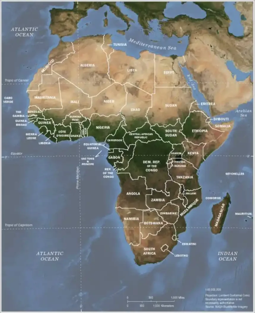
Last updated: September 2026
Interactive World Map: Africa's Location
Africa's Geographic Position on Earth
Because it is crossed by both the Equator (0° latitude) and the Prime Meridian (0° longitude), Africa lies in all four hemispheres: northern, southern, eastern and western. Most of its land, however, is in the Northern and Eastern Hemispheres. It extends from the Mediterranean coast of Tunisia in the north to Cape Agulhas in South Africa in the south, and from Senegal on the Atlantic to the Horn of Africa on the Indian Ocean.
Precise Coordinates and Boundaries
Northern Boundary: The northernmost point of Africa is Ras ben Sakka in Tunisia, located at approximately 37°21' North latitude. This point lies along the Mediterranean coast, making Africa's northern border primarily defined by the Mediterranean Sea and its proximity to southern Europe.
Southern Boundary: Cape Agulhas in South Africa marks the continent's southernmost point at 34°50' South latitude. This location is significant as it represents the geographical meeting point of the Atlantic and Indian Oceans, though the more famous Cape of Good Hope lies slightly northwest.
Western Boundary: The westernmost point of the mainland is Pointe des Almadies on the Cap-Vert peninsula near Dakar, Senegal, at about 17°32' West longitude. (Do not confuse the Cap-Vert peninsula with the island country of Cabo Verde, which lies about 570 km further west in the Atlantic.)
Eastern Boundary: Ras Hafun in Somalia represents the easternmost point at about 51°24' East longitude, extending into the Indian Ocean and marking Africa's eastern maritime frontier.
The Equatorial Divide
One of Africa's most distinctive geographic features is its position relative to the Equator. The Equator crosses the territory of seven African countries: São Tomé and Príncipe (at the islet of Ilhéu das Rolas), Gabon, the Republic of the Congo, the Democratic Republic of the Congo, Uganda, Kenya and Somalia. It also crosses Lake Victoria. Near the Equator, day length stays close to 12 hours all year.
The continent's equatorial position also influences its climate patterns significantly. The areas immediately north and south of the Equator experience tropical rainforest climates, while regions further from the Equator transition through savanna climates to more arid conditions in the Sahara Desert to the north and the Kalahari Desert to the south.
Africa's Relationship with Other Continents
Africa touches only one other continent by land (Asia, via the Sinai Peninsula) and lies within sight of a second (Europe, across the Strait of Gibraltar). The Americas are across the Atlantic, and Australia across the Indian Ocean.
Connection to Asia
Africa connects to Asia through the Isthmus of Suez. The Suez Canal (opened in 1869) is conventionally treated as the boundary, which places Egypt's Sinai Peninsula, bordering Israel and Gaza, in Asia and makes Egypt a transcontinental country. Further south, the Bab-el-Mandeb strait separates Djibouti and Eritrea from Yemen by only about 30 km.
This proximity has facilitated extensive cultural, economic, and demographic exchanges throughout history. The Indian Ocean coastline of East Africa has maintained trading relationships with Arabia, Persia, India, and other Asian regions for over two millennia, resulting in significant cultural influences and mixed populations, particularly along the Swahili coast.
Separation from Europe
The Mediterranean Sea separates Africa from Europe, with the narrowest gap being the Strait of Gibraltar between Morocco and Spain, measuring only 14 kilometers at its narrowest point. This relatively small water gap has never prevented extensive interaction between Africa and Europe, from ancient Phoenician and Roman periods through the colonial era to contemporary migration patterns.
The Mediterranean coastline of North Africa has historically been more connected to European and Middle Eastern civilizations than to Sub-Saharan Africa due to the barrier created by the Sahara Desert. Countries like Morocco, Algeria, Tunisia, Libya, and Egypt have maintained Mediterranean identities while remaining geographically African.
Distance from the Americas
Africa is separated from South America by the Atlantic Ocean, with the closest points being the westernmost part of Africa (in Senegal) and the easternmost part of South America (in Brazil), roughly 2,850 kilometers apart. This Atlantic crossing was crucial during the colonial period and the transatlantic slave trade, forcibly connecting African and American histories.
The distance to North America is considerably greater, with roughly 6,000 kilometers separating West Africa from the eastern United States coastline. Despite this distance, historical connections through trade, migration, and cultural exchange have created lasting bonds between Africa and the Americas.
Surrounding Oceans and Seas
Africa's position is defined not only by its land boundaries but also by the major bodies of water that surround it. These maritime boundaries have shaped the continent's climate, ecology, trade relationships, and human settlement patterns throughout history.
Atlantic Ocean - Western Boundary
The Atlantic Ocean forms Africa's entire western coast, from Morocco in the north to the Cape of Good Hope in South Africa.
Notable Atlantic Features: The Gulf of Guinea, the great bend in the coast from Côte d'Ivoire to Gabon, is where the Equator and Prime Meridian meet (at 0°, 0°) and is an important oil-producing and shipping region. The Canary Current flows southward along the northwest African coast, influencing climate patterns in countries like Morocco, Western Sahara, and Mauritania.
Indian Ocean - Eastern Boundary
The Indian Ocean defines Africa's eastern maritime boundary, extending from Somalia in the northeast to South Africa in the southeast. This ocean has been crucial for Africa's historical connections with Asia, facilitating trade routes that brought goods, ideas, and people from India, Arabia, Persia, and beyond.
East African Coast: The Swahili coast, stretching from Somalia to Mozambique, developed a unique culture blending African, Arab, and Asian influences due to centuries of Indian Ocean trade. The monsoon winds that characterize the Indian Ocean enabled predictable seasonal navigation, allowing traders to sail from Asia to Africa and back reliably.
Indian Ocean island countries counted as African are Madagascar, Mauritius, Seychelles and Comoros. Madagascar, the world's fourth-largest island, split from the African mainland roughly 160 million years ago. See the list of island countries in Africa.
Mediterranean Sea - Northern Boundary
The Mediterranean Sea forms Africa's northern coast, from Morocco to Egypt, and separates the continent from Europe. Major Mediterranean cities include Alexandria (Egypt), Tripoli (Libya), Tunis (Tunisia), Algiers (Algeria) and Tangier (Morocco). Casablanca, often listed here, is actually on Morocco's Atlantic coast.
Red Sea - Northeastern Boundary
The Red Sea, extending between Africa and Arabia, provides Africa's northeastern maritime boundary. This narrow sea, approximately 2,250 kilometers long and up to 355 kilometers wide, has been crucial for trade connections between Africa, Arabia, and the broader Asian world.
Since the Suez Canal opened, the Red Sea has been part of the main shipping route between the Mediterranean and the Indian Ocean. Its African coast belongs to Egypt, Sudan, Eritrea and Djibouti.
Geographic Features Defining Africa's Location
These landmarks are useful reference points when finding places on a map of Africa. For relief, rivers and deserts in more detail, see the physical map of Africa.
The Great Rift Valley
The Great Rift Valley system extends roughly 6,000 kilometers from southwest Asia through the Red Sea and into East Africa, where it splits into the Eastern and Western Rift Valleys.
The Eastern Rift Valley runs from Ethiopia through Kenya, Tanzania, and into Mozambique, creating a series of lakes, escarpments, and volcanic features. The Western Rift Valley curves through Uganda, Rwanda, Burundi, and the Democratic Republic of Congo, forming the African Great Lakes region. Rifting has produced Africa's highest volcanoes, including Kilimanjaro, and deep lakes such as Tanganyika.
Major Mountain Ranges
Atlas Mountains: Stretching about 2,500 km across Morocco, Algeria and Tunisia, the Atlas separate the Mediterranean and Atlantic coasts from the Sahara. The highest peak, Toubkal in Morocco, reaches 4,167 meters.
Ethiopian Highlands: Often called the "Roof of Africa," these highlands contain numerous peaks over 4,000 meters high, including Ras Dashen (Ras Dejen) at about 4,550 meters. The Ethiopian Highlands serve as the source of the Blue Nile and create a distinctive high-altitude region in northeastern Africa.
Drakensberg Mountains: Running along the eastern edge of South Africa and extending into Lesotho, the Drakensberg range creates a dramatic escarpment separating the interior plateau from the coastal regions. The highest peak, Thabana Ntlenyana in Lesotho, reaches 3,482 meters.
Desert Regions
Sahara Desert: The world's largest hot desert covers approximately 9 million square kilometers across northern Africa, from the Atlantic Ocean to the Red Sea. The Sahara serves as a significant geographic barrier, historically limiting interaction between North Africa and Sub-Saharan regions.
Kalahari Desert: Located in southern Africa, primarily in Botswana but extending into South Africa and Namibia, the Kalahari covers about 900,000 square kilometers. Unlike the Sahara, the Kalahari receives enough rainfall to support grasslands and sparse forests in many areas.
Namib Desert: Running along the Atlantic coast of Namibia, the Namib is considered the world's oldest desert, with some areas remaining arid for over 55 million years. This coastal desert creates unique ecological conditions where desert meets ocean.
Climate Zones and Africa's Location
Because Africa straddles the Equator, its climate zones roughly mirror each other north and south: rainforest at the centre, then savanna, then desert, then Mediterranean climate at the far north and far southwest.
Equatorial and Tropical Zones
The equatorial zone, extending roughly 5 degrees north and south of the Equator, experiences consistent temperatures throughout the year and high rainfall. This zone includes the Congo Basin rainforest, the second-largest tropical rainforest in the world, and creates the climatic conditions that support Africa's highest biodiversity.
Moving away from the Equator, tropical savanna climates dominate much of Sub-Saharan Africa, characterized by distinct wet and dry seasons. These regions support the famous African wildlife and the traditional pastoral and agricultural lifestyles that have shaped much of African culture.
Desert and Arid Zones
The subtropical high-pressure belts located approximately 20-30 degrees north and south of the Equator create Africa's major desert regions. The Sahara Desert in the north and the Kalahari Desert in the south result from these pressure systems, which prevent rainfall and create arid conditions.
Mediterranean and Subtropical Zones
The northern and southern extremes of Africa experience Mediterranean and subtropical climates respectively. The Mediterranean coast of North Africa shares climate characteristics with southern Europe, supporting similar agricultural products like olives, citrus fruits, and wheat.
South Africa's southwestern coast around Cape Town has a Mediterranean climate, while the east coast around Durban is humid subtropical.
Strategic Importance of Africa's Location
Africa's position between Europe, Asia and the Americas has long placed it on major trade routes.
Historical Trade Routes
Africa's location made it central to some of history's most important trade networks. Trans-Saharan trade routes connected Sub-Saharan Africa with North Africa and the Mediterranean world, facilitating the exchange of gold, salt, ivory, and slaves for manufactured goods, horses, and ideas.
The Indian Ocean trade network connected East Africa with Arabia, Persia, India, and beyond, bringing Islam, new crops, and trading practices to the African coast. These connections created the cosmopolitan Swahili culture and established cities like Kilwa, Mombasa, and Mogadishu as major commercial centers.
The Atlantic trade routes that developed after European exploration connected Africa with the Americas, initially through the devastating transatlantic slave trade but later through legitimate commerce in palm oil, peanuts, cocoa, and other products.
Modern Strategic Significance
Shipping Routes: The Suez Canal is the shortest sea route between Europe and Asia and in normal years carries roughly 12% of world trade. The longer Cape of Good Hope route around South Africa is the main alternative, and traffic shifted to it on a large scale when attacks on Red Sea shipping began in late 2023.
Military bases and naval facilities in locations like Djibouti (which hosts bases from multiple countries) demonstrate the continuing strategic importance of Africa's geographic position in global security considerations.
Africa's Size and Time Zones
Continental Comparisons
Africa is the second-largest continent by both area and population, covering approximately 30.3 million square kilometers (20% of Earth's total land area) and home to over 1.4 billion people. The United States, China, India and much of Europe would fit inside it, yet the common Mercator projection makes Africa look much smaller than it is, because it enlarges areas far from the Equator. See what Africa looks like on a map.
Time Zones and Africa's Position
African countries use six standard time offsets, from UTC−1 in Cabo Verde to UTC+4 in Mauritius and Seychelles; most of the mainland is on UTC+0 to UTC+3. The Prime Meridian crosses Algeria, Mali, Burkina Faso, Togo and Ghana, reaching the sea near Tema, east of Accra.
For the continent's regions, see North, West, Central, East and Southern Africa.
Frequently Asked Questions
Where is Africa located on a world map?
Africa lies south of Europe and southwest of Asia, between the Atlantic and Indian Oceans. It is the only continent crossed by both the Equator and the Prime Meridian, so it extends into all four hemispheres, although most of its land is in the Northern and Eastern Hemispheres.
What oceans surround Africa?
Africa is bordered by the Atlantic Ocean to the west, the Indian Ocean to the east and southeast, the Mediterranean Sea to the north, and the Red Sea to the northeast.
What continents are closest to Africa?
Europe lies just across the Strait of Gibraltar to the north (only 14 km from Morocco to Spain), and Asia connects to Africa via the Sinai Peninsula in Egypt.
Which countries does the Equator pass through in Africa?
The Equator crosses seven African countries: São Tomé and Príncipe, Gabon, the Republic of the Congo, the Democratic Republic of the Congo, Uganda, Kenya and Somalia.
How many countries are in Africa?
Africa has 54 UN-recognised sovereign countries. Western Sahara is a disputed territory and is not counted among them.
How big is Africa?
Africa is the world's second-largest continent at about 30.3 million km² — roughly three times the size of the United States and large enough to contain the US, China, India and most of Europe inside its borders.