What Does Africa Look Like on a Map?
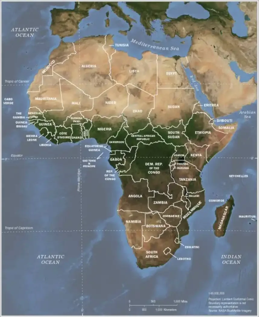
On a map, Africa looks like a wide, rounded block in the north that tapers to a point in the south, a bit like a question mark or an upside-down triangle. Its two most recognisable features are the Horn of Africa, jutting east into the Indian Ocean, and the sharp bend of the Gulf of Guinea on the west coast, which makes West Africa bulge into the Atlantic. The island of Madagascar sits off the southeast coast. Africa lies directly south of Europe, and the Equator crosses its middle.
Africa is much bigger than most world maps suggest: at about 30.3 million km² it is the second-largest continent, roughly 8,000 km from north to south and 7,400 km from west to east, and it contains 54 countries.
Last updated: September 2026
Interactive Map: Africa's True Shape and Features
The Shape of Africa
On a world map Africa is easy to pick out: a wide, blocky north that narrows to a point in the south, with two obvious features breaking the outline. On the east side the Horn of Africa juts into the Indian Ocean; on the west side the coast turns sharply at the Gulf of Guinea, leaving West Africa as a large bulge into the Atlantic. People often describe the shape as a question mark, a skull in profile, or an upside-down triangle sitting on a wide base.
The broad north
The northern half is the widest part of the continent, running about 7,400 km from Senegal's Atlantic coast to the tip of the Horn. Most of it is the Sahara, the world's largest hot desert at about 9 million km², nearly the size of the United States. The Mediterranean coast forms a fairly straight northern edge, broken by the Gulf of Sidra in Libya and the triangular Nile Delta in Egypt. In the northwest, Morocco reaches to within 14 km of Spain at the Strait of Gibraltar, and Tunisia pokes north towards Sicily.
The tapering south
South of the Equator the continent narrows steadily, ending at Cape Agulhas, the true southern tip, about 150 km southeast of the better-known Cape of Good Hope. Madagascar, the world's fourth-largest island at about 587,000 km², lies parallel to the southeast coast across the Mozambique Channel.
A smooth coastline
Compared with Europe or Asia, Africa's coastline is short for its size and has few deep bays, peninsulas or natural harbours. Estimates of its length range from roughly 26,000 to 30,000 km depending on how finely it is measured. The main exceptions to the smooth outline are the Horn, the Gulf of Guinea, the Nile and Niger deltas, and the Red Sea coast.
Features You Can See on Any Map of Africa
- Horn of Africa: the peninsula of Somalia, Ethiopia, Eritrea and Djibouti, pointing towards Arabia. Ras Hafun in Somalia is Africa's easternmost point.
- Gulf of Guinea: the right-angled bend in the west coast, lined by Côte d'Ivoire, Ghana, Togo, Benin, Nigeria and Cameroon. The Equator and Prime Meridian meet in its waters at 0°, 0°.
- West African bulge: the continent's westward projection, ending at Pointe des Almadies near Dakar, Senegal, the westernmost point of the mainland.
- Sahara: a vast tan or yellow area across the north on physical and satellite maps.
- The Nile: a thin green line running north through the desert of Sudan and Egypt to the Mediterranean. See where the Nile is on a map.
- Great Lakes and the Rift Valley: long, narrow rift lakes (Tanganyika, Malawi, Albert, Turkana) strung along the Great Rift Valley, and the broad, roughly round Lake Victoria between them, shared by Uganda, Kenya and Tanzania.
- Congo Basin: the deep green heart of Central Africa, the world's second-largest tropical rainforest.
- Madagascar and the islands: Madagascar off the southeast coast, with smaller island countries (Cabo Verde, São Tomé and Príncipe, Comoros, Mauritius, Seychelles) around the continent. The Canary Islands (Spain) and Réunion (France) are African geographically but belong to European countries.
Africa's True Size and Map Projections
Africa usually looks smaller than it is. The Mercator projection, used for many classroom maps and early web maps, keeps shapes correct locally but enlarges areas more and more towards the poles. Africa sits across the Equator, where Mercator distortion is smallest, so northern landmasses such as Europe, Russia, Canada and Greenland look far bigger by comparison. On a Mercator map Greenland looks roughly as big as Africa, although Africa is about 14 times larger.
Equal-area projections such as Gall–Peters, Mollweide or Equal Earth show areas correctly, and Africa then appears as the huge landmass it is. The Winkel tripel and Robinson projections are compromises that show Africa's size fairly and its shape with little distortion. A globe is the only view without any distortion.
Size comparisons
- Area: about 30.3 million km², roughly 20% of Earth's land area, second only to Asia.
- North–south: about 8,000 km from Tunisia to Cape Agulhas.
- East–west: about 7,400 km from Senegal to Somalia.
- What fits inside: the United States (about 9.8 million km²), China (about 9.6 million km²) and India (about 3.3 million km²) together cover about 22.7 million km², leaving room for much of Europe as well.
- Distances: Cairo to Cape Town is about 7,200 km in a straight line, farther than London to New York (about 5,600 km).
How Africa Looks on Different Types of Map
Political map
A political map shows Africa as a patchwork of 54 countries. Many borders are straight lines drawn during the colonial partition (see the Berlin Conference), especially across the Sahara. Look for Algeria, the largest country by area; the DR Congo, second largest; tiny Gambia, a strip along its river inside Senegal; Lesotho, entirely surrounded by South Africa; and Namibia's Caprivi Strip reaching east towards Zambia. Western Sahara is usually shown with a dashed border because its status is disputed. See the political map of Africa.
Physical map
A physical map shows that much of Africa is a high plateau, often above 1,000 m in the south and east, with narrow coastal plains. The Atlas Mountains form a ridge in the northwest, the Ethiopian Highlands a large brown mass in the east, the Rift Valley a chain of lakes and volcanoes including Kilimanjaro (5,895 m), and the Drakensberg a steep edge in the southeast. See the physical map of Africa.
Climate and vegetation maps
Because the Equator runs through the middle of the continent, climate and vegetation form bands that roughly mirror each other: rainforest in the Congo Basin and along the Gulf of Guinea, savanna to the north and south, then the Sahel and the Sahara in the north, and the Kalahari and Namib in the south, with Mediterranean climates at the far north coast and around Cape Town. The Ethiopian and East African highlands break the pattern with cooler, wetter conditions.
Satellite and night-time images
From space Africa shows the same bands: sand-coloured north and southwest, green centre, and the bright green thread of the Nile. At night, lights cluster along the Nile Valley and Delta, the Mediterranean coast, the Gulf of Guinea (especially Lagos) and South Africa's Gauteng province, while much of the interior is dark.
Common Misconceptions
- "Africa is about the size of Greenland." This comes from the Mercator projection; Africa is about 14 times larger.
- "Africa is mostly desert or jungle." Deserts cover roughly a third of the continent and rainforest a much smaller share; savanna and grassland are the most widespread landscapes, and there are glaciers on Kilimanjaro, Mount Kenya and the Rwenzori mountains near the Equator.
- "The Equator cuts Africa in half." It crosses near the middle of the continent's length, but about two-thirds of Africa's land lies north of the Equator because the northern part is so much wider.
- "Africa is a country." It is a continent of 54 independent countries with over 1.4 billion people.
Using the Interactive Map
Use the buttons above the map to show the continental outline, major features, the four extreme points, size comparisons or the main regions. Click any marker for a short description. For region-level maps, see North, West, Central, East and Southern Africa, or read where Africa is located on the world map.
Frequently Asked Questions
What does Africa look like on a map?
Africa is the second-largest continent and appears as a roughly triangular landmass straddling the equator. It bulges westward into the Atlantic in West Africa and tapers to a southern point at the Cape of Good Hope. The Horn of Africa juts eastward into the Indian Ocean.
Why does Africa look smaller on most world maps?
Most world maps use the Mercator projection, which distorts size near the poles and makes equatorial regions like Africa look smaller than they actually are. Africa is in fact large enough to fit the US, China, India and most of Europe inside its borders.
How long and wide is Africa?
Africa is about 8,000 km from north (Ras ben Sakka, Tunisia) to south (Cape Agulhas, South Africa) and about 7,400 km from west (Senegal) to east (Ras Hafun, Somalia). Its area is about 30.3 million km².
What are Africa's most recognizable map features?
The Sahara Desert across the north, the Horn of Africa pointing into the Indian Ocean, Madagascar off the southeast coast, the Nile River running northward through Egypt, and the Cape at the southern tip are all distinctive features.