Where Is Rwanda on the Map of Africa?
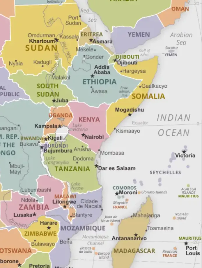
Rwanda is located in east-central Africa, about 120 km south of the Equator, in the African Great Lakes region. It is a small, landlocked country known as the "Land of a Thousand Hills". Its neighbours are Uganda to the north, Tanzania to the east, Burundi to the south and the Democratic Republic of the Congo to the west, where Lake Kivu forms much of the border. Its centre is at about 2°S, 30°E. Rwanda covers 26,338 km² and has about 14 million people (2024 estimate), which makes it one of the most densely populated countries in Africa. The capital is Kigali. Rwanda is usually counted as part of East Africa (it is in the UN's Eastern Africa region) and belongs to the East African Community.
Last updated: September 2026
Interactive Map: Rwanda's Location in East Africa
Rwanda's Precise Location in East Africa
On a map of Africa, find Lake Victoria and then look west. Rwanda is the small country between Lake Victoria and Lake Kivu, directly north of Burundi and south-west of Uganda.
Geographic Coordinates
Rwanda is positioned between approximately 1°04'S to 2°51'S latitude and 28°50'E to 30°53'E longitude. This places the country just south of the Equator, giving it a tropical highland climate moderated by its high elevation. The country's centre lies at approximately 2°S, 30°E, near Muhanga (formerly Gitarama).
Key coordinate points include:
- Northernmost point: Near Rukomo in Nyagatare District (1°04'S)
- Southernmost point: Near Akanyaru River in Gisagara District (2°51'S)
- Easternmost point: Near Kagitumba border with Tanzania (30°53'E)
- Westernmost point: Near Lake Kivu shore in Rusizi District (28°50'E)
Regional Context
Within the broader East African context, Rwanda sits at the intersection of several important geographic and cultural regions. The country is part of the East African Community (EAC). The Congo–Nile divide runs north to south through western Rwanda. About two-thirds of the country drains east via the Akagera River into Lake Victoria and the Nile, and the rest drains west via Lake Kivu and the Rusizi River to Lake Tanganyika and the Congo.
Rwanda's location places it:
- Roughly 1,100–1,200 km west of the Indian Ocean coast
- About 2,000 km from the Atlantic Ocean
- About 120 km south of the Equator at its closest point
- On Central Africa Time (UTC+2), one hour behind Kenya, Uganda and Tanzania
Neighboring Countries and Borders
Rwanda shares borders with four countries, each contributing to the nation's cultural and economic relationships. Understanding these borders helps locate Rwanda on regional maps and appreciate its role in East African geopolitics.
Democratic Republic of Congo (West)
Rwanda's border with the Democratic Republic of the Congo (DRC) stretches about 221 kilometres along the western edge. This border runs primarily along Lake Kivu and the Rusizi River valley. The border region is mountainous and includes part of the Albertine Rift, one of Africa's most biodiverse regions.
Key border features with DRC include:
- Lake Kivu forming much of the natural boundary
- Goma-Gisenyi twin cities at the northern end
- Cyangugu-Bukavu crossing in the south
Uganda (North)
The northern border with Uganda is the shortest, at about 172 kilometres, and running through varied terrain from mountains in the west to savanna in the east. This border is historically significant as a major route for trade and migration between East and Central Africa.
Important border crossings and features include:
- Gatuna/Katuna - the main border crossing
- Cyanika border post in the western mountains
- Kagitumba crossing in the eastern region
- Shared Virunga Mountains in the northwest
Tanzania (East)
Rwanda's eastern border with Tanzania runs for approximately 222 kilometers, primarily through savanna and highland regions. This border represents Rwanda's main connection to the broader East African region and the Indian Ocean trade routes.
Key features of the Tanzania border:
- Rusumo Falls on the Kagera River
- Akagera National Park extending to the border
- Rolling hills and wetland areas
- Traditional trade routes to the coast
Burundi (South)
The longest border is with Burundi to the south, at about 315 kilometres. Nyungwe Forest continues across it into Burundi's Kibira National Park. This border runs through similar highland terrain and reflects the shared cultural and linguistic heritage of both countries.
Notable border characteristics:
- Akanyaru River forming part of the boundary
- Shared hills and river valleys
- Cultural and linguistic similarities across the border
- Multiple small border crossings
The Great Lakes Region Context
Rwanda's location within the African Great Lakes region is fundamental to understanding its geography, history, and culture. This region is one of Africa's most important areas both geographically and historically.
Geographic Significance
The Great Lakes region encompasses the area around Africa's largest lakes, including Lake Victoria, Lake Tanganyika, Lake Kivu, and others. Rwanda sits at the heart of this region, sharing Lake Kivu with the DRC and being within the broader watershed systems that feed these great lakes.
Rwanda's role in the Great Lakes system includes:
- Part of the Nile River watershed through the Nyabarongo River
- Contributing to the Congo River system through western drainage
- Sharing Lake Kivu, one of Africa's deepest lakes
- Located on the Congo–Nile divide, which separates Atlantic-bound from Mediterranean-bound drainage
Geological Context
Rwanda's position in the Great Lakes region places it within the Albertine Rift, part of the larger East African Rift System. This geological activity has created the country's mountainous terrain and contributed to its reputation as the "Land of a Thousand Hills."
Geological features include:
- Volcanic mountains in the northwest (Virunga range)
- Rift valley systems creating Lake Kivu
- Highland plateaus throughout the central regions
- Escarpments and river valleys
Biodiversity Hotspot
The Great Lakes region, including Rwanda, is recognized as one of Africa's most important biodiversity hotspots. Rwanda's location provides habitat for mountain gorillas, forest elephants, and numerous endemic species.
Rwanda's Physical Geography and Terrain
Rwanda's nickname "Land of a Thousand Hills" accurately describes its varied topography, which ranges from highland plateaus to mountain peaks and river valleys.
Elevation and Topography
Rwanda has an average elevation of about 1,600 metres above sea level, making it one of Africa's highest countries. The elevation ranges from about 950 metres in the Rusizi River valley in the south-west, through about 1,460 metres at Lake Kivu, to 4,507 metres at the summit of Karisimbi volcano.
Topographic regions include:
- Virunga Mountains (Northwest): Volcanic peaks including Karisimbi, Bisoke, and Muhabura
- Central Plateau: Rolling hills and valleys around Kigali
- Eastern Savanna: Lower elevation plains in Akagera region
- Western Rift Valley: Lake Kivu and surrounding mountains
- Southern Highlands: Nyungwe Forest region
Climate Zones
Due to its elevation and position near the Equator, Rwanda experiences a temperate tropical highland climate with distinct wet and dry seasons.
Climate characteristics:
- Average temperature: 16-20°C year-round
- Two rainy seasons: March-May and October-December
- Cooler temperatures in highland areas
- Relatively stable climate due to equatorial location
River Systems and Watersheds
Rwanda sits on the Congo–Nile divide. Water from the east of the country eventually reaches the Mediterranean via the Nile, and water from the west reaches the Atlantic via the Congo.
Major river systems:
- Nyabarongo River: Rises near Nyungwe, loops through central Rwanda and joins the Akagera; considered one of the most remote headstreams of the Nile
- Rusizi River: Drains Lake Kivu south into Lake Tanganyika and the Congo system
- Akagera River: Forms eastern border, flows to Lake Victoria
- Mwogo River: Tributary of the Nyabarongo system
Major Cities and Urban Centers
Rwanda's urban centers are distributed across the country's hills and valleys, with each major city serving specific regional and national functions.
Kigali - The Capital
Kigali, Rwanda's capital and largest city, is located in the center of the country at approximately 1°57'S, 30°04'E. The city sits on several hills at an elevation of about 1,567 meters, providing a central location for national administration and commerce.
Kigali's geographic significance:
- Central location within Rwanda
- Hub for regional transportation networks
- International airport connecting to East Africa and beyond
- Growing technology and financial center
Other Major Cities
Butare (Huye): Located in southern Rwanda, this city serves as an important educational center and is home to the main campus of the University of Rwanda (formerly the National University of Rwanda). Its position in the southern highlands makes it a regional hub for agriculture and education.
Gisenyi (Rubavu): Situated on the shores of Lake Kivu near the DRC border, Gisenyi is Rwanda's main lakeside resort town and an important border crossing point. The city's location makes it crucial for trade with eastern DRC.
Ruhengeri (Musanze): Located in northern Rwanda near Volcanoes National Park, this city serves as the gateway to mountain gorilla tourism and the Virunga Mountains.
Cyangugu (Rusizi): Positioned at the southern end of Lake Kivu, this city is another important border town with the DRC and serves the southern lake region.
National Parks and Protected Areas
Rwanda's location provides diverse ecosystems that are protected within several national parks, each representing different aspects of the country's natural heritage.
Volcanoes National Park (Northwest)
Located in the Virunga Mountains along the borders with Uganda and DRC, this park protects mountain gorilla habitat and includes several volcanic peaks. The park's location at Rwanda's highest elevations creates unique montane ecosystems.
Key features:
- Home to endangered mountain gorillas
- Volcanic peaks up to 4,507 meters
- Bamboo and alpine vegetation zones
- Cross-border conservation area
Nyungwe National Park (Southwest)
This montane rainforest park in southwestern Rwanda represents one of Africa's oldest and most biodiverse forests. Its location in the highlands provides habitat for numerous primate species and endemic plants.
Significant features:
- Ancient montane rainforest
- 13 primate species including chimpanzees
- Source of major river systems
- Canopy walkway for forest exploration
Akagera National Park (East)
Located along Rwanda's eastern border with Tanzania, this park protects savanna, woodland, and wetland ecosystems. The park's location in lower-elevation areas provides different habitats from Rwanda's highland parks.
Park characteristics:
- Savanna and woodland ecosystems
- Lions (reintroduced in 2015) and black and white rhinos (reintroduced from 2017)
- Wetland areas along rivers and lakes
- Big Five wildlife viewing
Historical Significance of Rwanda's Location
Rwanda's position in the heart of East Africa has shaped its history, from ancient kingdoms to modern times.
Ancient Kingdoms
Rwanda's central location made it a meeting point for different African cultures and migration patterns. The Kingdom of Rwanda developed as a sophisticated state that controlled the highland areas and established trade relationships with neighboring regions.
Historical significance includes:
- Strategic position for controlling regional trade routes
- Cultural synthesis of Bantu and other African traditions
- Development of unique social and political systems
- Resistance to foreign invasion due to terrain
Colonial Period
Rwanda became part of German East Africa in the 1890s. After the First World War, Belgium ran it with Burundi as the League of Nations mandate (later UN trust territory) of Ruanda-Urundi. Rwanda became independent on 1 July 1962. In 1994 about 800,000 people, most of them Tutsi, were killed in the genocide against the Tutsi. Since then the country has rebuilt and become one of the region's faster-growing economies.
Modern Strategic Importance
Today, Rwanda's location continues to provide strategic advantages:
- Regional hub for East African integration
- Conference and meeting center for African organizations
- Gateway between Central and East Africa
- Model for sustainable development in the region
Economic Significance of Rwanda's Position
Rwanda's location provides both opportunities and challenges for economic development, influencing trade, tourism, and regional integration.
Trade and Transportation
As a landlocked country, Rwanda's location requires careful management of trade relationships and transportation networks. The country has developed strong connections to regional ports and transportation corridors.
Key trade routes include:
- Northern Corridor through Uganda to Mombasa port
- Central Corridor through Tanzania to Dar es Salaam
- Western links to eastern DRC via Goma and Bukavu
- Regional air connections through Kigali airport
Tourism Assets
Rwanda's location provides diverse tourism opportunities, from mountain gorillas to savanna wildlife, cultural experiences, and conference tourism.
Tourism advantages:
- Unique mountain gorilla experiences
- Diverse ecosystems within a small area
- Safe and accessible tourism infrastructure
- Regional hub for business and conference tourism
Regional Integration
Rwanda's central location makes it an ideal hub for regional organizations and integration initiatives. The country hosts numerous African institutions and serves as a bridge between different regions.
Cultural and Linguistic Context
Rwanda's location at the intersection of different African regions has created a unique cultural synthesis while maintaining distinct national characteristics.
Language and Culture
Rwanda has four official languages: Kinyarwanda, which almost everyone speaks, plus English, French and Swahili. English replaced French as the main language of education in 2008, and Swahili became official in 2017.
Cultural influences from location:
- Bantu cultural traditions from broader regional heritage
- Unique Rwandan traditions adapted to highland environment
- Integration of East African and Central African elements
- Modern cosmopolitan influences from regional integration
Religious and Social Systems
The country's location has facilitated the spread of various religious and social influences while maintaining traditional belief systems adapted to the highland environment.
Climate and Environmental Characteristics
Rwanda's location near the Equator combined with its high elevation creates unique environmental conditions that influence agriculture, lifestyle, and natural resource management.
Agricultural Zones
Different elevation zones within Rwanda support various agricultural activities:
- Highland zones (above 2,000m): Potato cultivation and pyrethrum
- Medium elevations (1,500-2,000m): Coffee, tea, and food crops
- Lower areas (below 1,500m): Cassava, sorghum, and livestock
- Wetland areas: Rice cultivation and aquaculture
Environmental Challenges and Opportunities
Rwanda's location presents both environmental challenges and opportunities:
- High population density requiring intensive land use
- Terraced agriculture adapted to hilly terrain
- Forest conservation in biodiversity hotspots
- Renewable energy potential from geography
Finding Rwanda on Different Maps
Understanding how to locate Rwanda on various types of maps helps appreciate the country's position and significance within Africa.
Political Maps
On political maps of Africa, Rwanda appears as a small, compact country in the east-central region. Look for it between the much larger Democratic Republic of Congo and Tanzania, north of Burundi and south of Uganda.
Physical Maps
Physical maps show Rwanda's highland character through elevation coloring, typically appearing in brown or orange tones indicating high elevation. The country's position in the Great Lakes region is evident from surrounding water bodies.
Regional Maps
East African regional maps show Rwanda as part of the Great Lakes region, connected to broader regional systems and transportation networks.
Thematic Maps
Various thematic maps highlight different aspects of Rwanda's location:
- Population density maps showing high density despite small size
- Economic maps showing regional trade connections
- Environmental maps highlighting biodiversity hotspots
- Transportation maps showing regional connectivity
Related Maps and Pages
See the East Africa map and the Central Africa map for the wider region, and the Great Rift Valley map for the Albertine Rift, where Lake Kivu lies. Country profiles: Rwanda, Burundi, Uganda, Tanzania.
Frequently Asked Questions
Where is Rwanda on the map of Africa?
Rwanda is a small landlocked country in east-central Africa, about 120 km south of the Equator. It borders Uganda, Tanzania, Burundi and the Democratic Republic of the Congo, between Lake Victoria and Lake Kivu.
What is the capital of Rwanda?
Kigali is the capital and largest city of Rwanda. It sits on several hills near the centre of the country, at about 1,567 m above sea level.
Is Rwanda in East Africa?
Yes. Rwanda is a member of the East African Community along with Kenya, Tanzania, Uganda, Burundi, South Sudan, DR Congo and Somalia, and is usually listed as part of East Africa.
How big is Rwanda?
Rwanda covers 26,338 km², slightly smaller than Belgium. It has about 14 million people, making it one of Africa's most densely populated countries.
Which lake is on Rwanda's border?
Lake Kivu forms most of Rwanda's western border with the DR Congo. Rwanda has no shore on Lake Victoria, which lies to the east in Uganda and Tanzania.