Where Is South Africa Located on a Map?
South Africa is located at the southernmost tip of the African continent, occupying a strategic position where the Atlantic and Indian Oceans meet. It lies entirely in the Southern Hemisphere, between about 22°S and 35°S latitude and 16°E and 33°E longitude, and covers about 1.22 million km². Its neighbours are Namibia to the north-west, Botswana to the north, Zimbabwe to the north-east, and Mozambique and Eswatini to the east. It completely surrounds Lesotho. On a world map, look directly south of the Congo Basin and roughly 4,000 km north of the Antarctic coast. Cape Agulhas, in the Western Cape, is the southernmost point of Africa. For a province-by-province map, see our South Africa map.
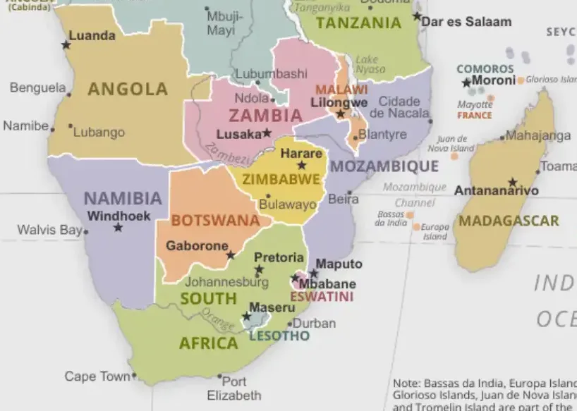
Last updated: September 2026
Interactive Map: South Africa's Location and Geography
South Africa's Position at Africa's Southern Tip
South Africa is the only African country with long coastlines on both the Atlantic and the Indian Ocean. Ships sailing between Europe or the Americas and Asia have rounded its capes since the 15th century.
Geographic Coordinates and Extent
South Africa spans from approximately 22°07'S to 34°50'S latitude and from 16°28'E to 32°53'E longitude. This places the entire country in the Southern Hemisphere, so its seasons are the opposite of those in Europe and North America. It uses a single time zone, South African Standard Time (UTC+2).
Key geographic points include:
- Northernmost point: On the Limpopo River near Pafuri, in the far north of Kruger National Park (about 22°08'S)
- Southernmost point: Cape Agulhas, the true southern tip of Africa (34°50'S)
- Easternmost point: Near Kosi Bay in KwaZulu-Natal (32°53'E)
- Westernmost point: Near Alexander Bay on the Orange River (16°28'E)
Regional Context
South Africa belongs to the Southern Africa region and is the largest economy in the Southern African Development Community (SADC) and the Southern African Customs Union (SACU), which it shares with Botswana, Lesotho, Namibia and Eswatini.
South Africa's location provides:
- Access to both Atlantic and Indian Ocean shipping routes
- A Mediterranean climate zone in the southwestern cape
- A gateway for Antarctic research: Cape Town is a staging port for several national Antarctic programmes
- Strategic position for trade with Asia, Europe, and the Americas
Neighboring Countries and International Borders
South Africa shares borders with six countries, each relationship shaped by historical, economic, and geographic factors. Understanding these borders helps locate South Africa within the southern African regional context.
Namibia (Northwest Border)
The border with Namibia runs for approximately 1,005 kilometers along South Africa's northwestern edge. Much of this border follows the Orange River, which serves as a natural boundary between the two countries. The border region is characterized by arid landscapes and important mining activities.
Key border features:
- Orange River forming much of the natural boundary
- Richtersveld and Fish River Canyon region
- Alexander Bay border crossing
- Diamond mining areas along the coast
Botswana (North Border)
South Africa's border with Botswana extends for about 1,969 kilometers along the northern frontier. This border runs through the Kalahari Desert region and includes some of South Africa's most remote and sparsely populated areas.
Notable border characteristics:
- Kalahari Desert landscape
- Molopo River forming part of the boundary
- Multiple border crossings including Ramatlabama
- Shared conservation areas and transfrontier parks
Zimbabwe (Northeast Border)
The Zimbabwe border runs for approximately 230 kilometers along the Limpopo River. This is one of South Africa's busiest borders due to economic migration and trade relationships between the two countries.
Border highlights:
- Limpopo River as natural boundary
- Beit Bridge - major border crossing and trade route
- Kruger National Park extending to the border
- Historical and cultural connections
Mozambique (East Border)
South Africa shares a 496-kilometer border with Mozambique along its eastern edge. This border provides South Africa with important access to Indian Ocean ports and has significant implications for regional trade.
Key features:
- Multiple border crossings including Komatipoort and Lebombo
- Maputo port providing alternative shipping access
- Kruger National Park extending across the border
- Shared river systems and conservation areas
Eswatini (East Border)
The border with Eswatini (formerly Swaziland) runs for about 438 kilometers. This small kingdom is almost entirely surrounded by South Africa, with only a small border with Mozambique providing alternative access.
Lesotho (Completely Surrounded)
Unique among world geography, Lesotho is completely surrounded by South Africa, making it one of only three enclaved countries in the world. The border with Lesotho extends for approximately 1,106 kilometers through the Drakensberg Mountains and surrounding highlands.
Special characteristics:
- Mountain kingdom entirely within South Africa
- Multiple border crossings through mountain passes
- Shared river systems including the Orange River source
- Economic integration and customs union
South Africa's Nine Provinces
South Africa is divided into nine provinces, each with distinct geographic characteristics, economic activities, and cultural identities. Understanding the provincial layout helps navigate South Africa's internal geography.
Western Cape
Located in the southwestern corner, the Western Cape is home to Cape Town and features a Mediterranean climate. This province includes the famous Cape Winelands, Table Mountain, and the Cape of Good Hope.
Key features:
- Cape Town - legislative capital and major port
- Cape Winelands and agricultural regions
- Garden Route coastal tourism area
- Cape Floral Kingdom biodiversity hotspot
Eastern Cape
The Eastern Cape extends along the Indian Ocean coast and includes major ports like Port Elizabeth (now Gqeberha) and East London. This province features diverse landscapes from coastal areas to mountainous regions.
Notable characteristics:
- Major automotive manufacturing centers
- Rich cultural heritage and historical sites
- Diverse landscapes from coast to mountains
- Important agricultural regions
KwaZulu-Natal
Located along the eastern coast, KwaZulu-Natal includes Durban, South Africa's busiest port. The province features the Drakensberg Mountains, numerous game reserves, and beautiful coastal areas.
Key features:
- Durban - major port and industrial center
- Drakensberg Mountains and World Heritage sites
- Battlefield tourism areas
- Significant Zulu cultural heritage
Gauteng
The smallest province by area but largest by population, Gauteng is the economic heart of South Africa. This inland province includes Johannesburg and Pretoria and generates about a third of the country's GDP.
Economic significance:
- Johannesburg - largest city and financial center
- Pretoria - executive capital
- OR Tambo International Airport - continental hub
- Mining industry headquarters
Free State
Located in the central part of the country, the Free State is characterized by vast grasslands and is known for its agricultural production and gold mining activities.
North West Province
This province borders Botswana and includes important mining areas, particularly platinum mining around Rustenburg. It also features the popular Sun City resort complex.
Northern Cape
The largest province by area, the Northern Cape covers much of the Kalahari Desert and includes important diamond mining areas around Kimberley.
Mpumalanga
Located in the northeast, Mpumalanga includes a significant portion of the Kruger National Park and is known for its scenic beauty, including the Blyde River Canyon.
Limpopo
The northernmost province, Limpopo borders three countries (Zimbabwe, Botswana, and Mozambique) and includes important agricultural areas and part of the Kruger National Park.
Major Cities and Urban Centers
South Africa's major cities are distributed across the country, each serving specific economic and administrative functions that reflect the country's complex geography and history.
The Three Capitals
Uniquely, South Africa has three capital cities, each serving different governmental functions:
Cape Town (Legislative Capital): Located at 33°55'S, 18°25'E in the Western Cape, Cape Town houses the National Parliament. The city sits beneath Table Mountain and between Table Bay and False Bay, creating one of the world's most scenic urban settings.
Pretoria (Executive Capital): Located at 25°45'S, 28°12'E in Gauteng, Pretoria serves as the executive capital housing the Union Buildings and most government departments. The city lies about 55 km north of Johannesburg, just north of the Witwatersrand, and the two cities have grown into one urban region.
Bloemfontein (Judicial Capital): Located at 29°07'S, 26°13'E in the Free State, Bloemfontein houses the Supreme Court of Appeal and serves as the judicial capital.
Major Metropolitan Areas
Johannesburg: South Africa's largest city and economic center, located at 26°12'S, 28°03'E. Known as the "City of Gold," Johannesburg developed around gold mining and remains the continental financial hub.
Durban: The country's busiest port and third-largest city, located at 29°52'S, 31°01'E on the Indian Ocean coast. Durban handles much of South Africa's international trade and serves as a gateway to the interior.
Port Elizabeth (Gqeberha): An important port and automotive manufacturing center located at 33°58'S, 25°36'E on the Indian Ocean coast in the Eastern Cape.
Other Important Cities
- East London: Major port in the Eastern Cape
- Kimberley: Historic diamond mining city in the Northern Cape
- Nelspruit (Mbombela): Gateway to Kruger National Park
- Polokwane: Capital of Limpopo province
- Rustenburg: Major platinum mining center
Coastal Geography and Maritime Boundaries
South Africa's position between two oceans gives it one of the continent's longest and most diverse coastlines, stretching 2,798 kilometers and offering numerous ports, beaches, and marine ecosystems.
Atlantic Coast (West)
The Atlantic coastline extends from the Orange River mouth in the north to Cape Agulhas in the south, covering approximately 1,200 kilometers. This coast is influenced by the cold Benguela Current, creating cooler water temperatures and supporting rich marine life.
Key Atlantic coastal features:
- Cape Town harbor and surrounding bays
- West Coast National Park and marine sanctuaries
- Important fishing grounds and marine resources
- Unique coastal desert and Mediterranean climate zones
Indian Ocean Coast (East)
The Indian Ocean coastline runs from Cape Agulhas to the Mozambique border, covering about 1,600 kilometers. This coast benefits from the warm Agulhas Current, creating warmer waters and subtropical conditions.
Notable Indian Ocean features:
- Major ports including Durban, Gqeberha (Port Elizabeth), Ngqura and East London
- Popular beach destinations along KwaZulu-Natal
- Rich marine biodiversity and whale watching areas
- Important shipping routes to Asia and Australia
Cape Agulhas - Where Oceans Meet
Cape Agulhas represents the southernmost point of the African continent and the official meeting point of the Atlantic and Indian Oceans. This location is marked by a monument and represents a significant geographic landmark.
Significance of Cape Agulhas:
- Southernmost point of Africa at 34°50'S
- Official Atlantic-Indian Ocean boundary
- Important navigation landmark for shipping
- Unique marine and terrestrial ecosystems
Physical Geography and Topography
South Africa's diverse topography includes coastal plains, mountain ranges, high plateaus, and semi-arid regions, creating a variety of ecosystems and climatic zones within a single country.
The Great Escarpment
The Great Escarpment is South Africa's most significant topographic feature, running roughly parallel to the coast and separating the coastal lowlands from the interior plateau. This escarpment includes several mountain ranges and creates dramatic landscape changes.
Major mountain ranges:
- Drakensberg Mountains: The highest range, extending along the eastern escarpment
- Cape Fold Mountains: Creating the scenic landscapes around Cape Town
- Swartberg Mountains: Running east-west through the Western Cape
- Magaliesberg: Ancient mountain range north of Johannesburg
The Interior Plateau
Much of South Africa consists of a high interior plateau, known as the Highveld, with elevations typically above 1,200 meters. This plateau contains the country's main population centers and economic activities.
Plateau regions:
- Highveld: High grassland plateau including Johannesburg
- Middleveld: Intermediate elevation areas
- Bushveld: Lower-lying savanna regions in the north
- Karoo: Semi-arid plateau in the central regions
River Systems
South Africa's river systems drain toward both the Atlantic and Indian Oceans, reflecting the country's position between these major water bodies.
Major rivers:
- Orange River: Longest river, flowing west to the Atlantic
- Limpopo River: Northern border river flowing to the Indian Ocean
- Vaal River: Major tributary of the Orange River
- Tugela River: Major KwaZulu-Natal river system
Climate Zones and Environmental Diversity
South Africa's location and topographic diversity create multiple climate zones and ecosystems, from Mediterranean climates to semi-deserts, supporting remarkable biodiversity.
Mediterranean Climate Zone
The southwestern Cape around Cape Town experiences a Mediterranean climate with wet winters and dry summers. This climate supports unique vegetation known as fynbos and enables wine production.
Subtropical and Temperate Zones
The eastern coastal areas experience subtropical conditions with warm, humid summers and mild winters. The interior plateau has a more temperate climate with distinct seasonal variations.
Semi-Arid and Arid Zones
The western and northwestern regions experience semi-arid to arid conditions, influenced by the cold Benguela Current and continental high-pressure systems.
Biodiversity Hotspots
South Africa contains portions of three global biodiversity hotspots:
- Cape Floral Kingdom: Unique fynbos vegetation in the Western Cape
- Succulent Karoo: Arid region with high plant endemism
- Maputaland-Pondoland-Albany: Coastal and interior eastern regions
Economic Geography and Natural Resources
South Africa's location has made it a center for mining, agriculture, and maritime trade, with natural resources distributed across different provinces reflecting underlying geology.
Mining Regions
South Africa's mineral wealth is legendary, with different regions specializing in various minerals:
- Witwatersrand (Gauteng): Gold mining center
- Bushveld Complex (North West/Limpopo): Platinum and chrome
- Northern Cape: Diamonds and iron ore
- Mpumalanga: Coal mining
- Western Cape: Limestone and sand minerals
Agricultural Zones
Different climate zones support various agricultural activities:
- Western Cape: Wine production and Mediterranean crops
- Free State: Maize and wheat production
- KwaZulu-Natal: Sugar cane and subtropical fruits
- Northern provinces: Cattle ranching and game farming
Maritime Economy
South Africa's strategic location supports a significant maritime economy:
- Major shipping routes between Asia, Europe, and the Americas
- Important fishing industry on both coasts
- Offshore oil and gas exploration
- Marine tourism and recreation
Historical Significance of South Africa's Location
South Africa's strategic position has shaped its history from early human settlement through colonial periods to modern times.
Early Settlement and Trade
South Africa's location made it a natural stopping point on the sea route between Europe and Asia. The Portuguese navigator Bartolomeu Dias rounded the Cape in 1488 and called it the "Cape of Storms". It was renamed the Cape of Good Hope because it opened the route to India, which Vasco da Gama completed in 1497–98.
Colonial Period
The Dutch East India Company established a refreshment station at the Cape in 1652, taking advantage of the location's strategic importance for Asian trade. Later British control reflected the cape's continuing significance for imperial communications.
Modern Strategic Importance
Today, South Africa's location continues to provide strategic advantages:
- Regional economic hub for southern Africa
- Gateway for international investment in Africa
- Important shipping routes for global trade
- Bridge between African and global markets
Finding South Africa on Different Maps
Understanding how to locate South Africa on various types of maps helps appreciate the country's position and significance within Africa and globally.
Political Maps
On political maps of Africa, South Africa appears at the continent's southern tip as one of the largest and most recognizable countries. Its distinctive shape, with Lesotho as an enclave, makes it easily identifiable.
Physical Maps
Physical maps reveal South Africa's topographic diversity through elevation coloring, showing the Great Escarpment, coastal plains, and interior plateau. The country's position between two oceans is clearly visible.
Climate Maps
Climate maps show South Africa's diverse climate zones, from Mediterranean in the southwest to subtropical in the east and semi-arid in the interior and west.
Economic Maps
Economic maps highlight South Africa's role as the dominant economy in southern Africa, with major mining areas, industrial centers, and transportation networks clearly marked.
Related Maps and Pages
See the South Africa map for provinces, parks and wine regions, the Southern Africa map for the wider region, and the Kalahari Desert map for the arid north-west. Country profiles: South Africa, Lesotho, Eswatini. Capitals: Pretoria and Cape Town.
Frequently Asked Questions
Where is South Africa on the map of Africa?
South Africa occupies the southern tip of the African continent. It borders Namibia, Botswana, Zimbabwe, Mozambique and Eswatini, and Lesotho is entirely enclosed within its territory.
Which oceans border South Africa?
The Atlantic Ocean borders the west coast and the Indian Ocean the south and east coasts. The two oceans officially meet at Cape Agulhas, the southernmost point of Africa.
Is the Cape of Good Hope the southern tip of Africa?
No. The southernmost point is Cape Agulhas, about 150 km south-east of the Cape of Good Hope. The Cape of Good Hope is the south-western tip of the Cape Peninsula.
How many capitals does South Africa have?
South Africa has three capitals: Pretoria (executive), Cape Town (legislative) and Bloemfontein (judicial). Johannesburg is the largest city but not a national capital.
What is the population of South Africa?
South Africa has about 63 million people (2024 estimate). It is the most populous country in Southern Africa.